You are here: Home > Network List > TA - USArray Transportable Network (new EarthScope stations) Stations List
> Station X20A Quemado, NM, USA > Earthquake Result Viewer
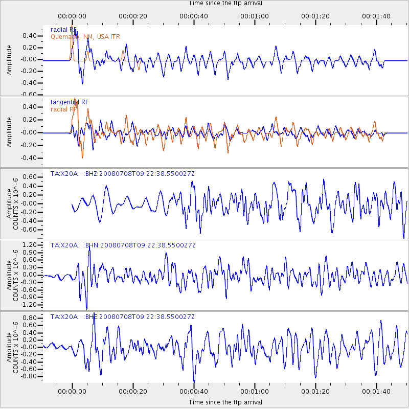
X20A Quemado, NM, USA - Earthquake Result Viewer
*The percent match for this event was below the threshold and hence no stack was calculated.
| Earthquake location: |
Southern Peru |
| Earthquake latitude/longitude: |
-16.0/-71.7 |
| Earthquake time(UTC): |
2008/07/08 (190) 09:13:07 GMT |
| Earthquake Depth: |
123 km |
| Earthquake Magnitude: |
5.8 MB, 6.2 MW, 6.2 MW |
| Earthquake Catalog/Contributor: |
WHDF/NEIC |
|
| Network: |
TA USArray Transportable Network (new EarthScope stations) |
| Station: |
X20A Quemado, NM, USA |
| Lat/Lon: |
34.54 N/108.50 W |
| Elevation: |
2057 m |
|
| Distance: |
61.2 deg |
| Az: |
325.695 deg |
| Baz: |
138.953 deg |
| Ray Param: |
$rayparam |
*The percent match for this event was below the threshold and hence was not used in the summary stack. |
|
| Radial Match: |
72.916695 % |
| Radial Bump: |
332 |
| Transverse Match: |
58.90893 % |
| Transverse Bump: |
400 |
| SOD ConfigId: |
2504 |
| Insert Time: |
2010-03-06 13:44:07.976 +0000 |
| GWidth: |
2.5 |
| Max Bumps: |
400 |
| Tol: |
0.001 |
|
Signal To Noise
| Channel | StoN | STA | LTA |
| TA:X20A: :BHN:20080708T09:22:38.550027Z | 6.827733 | 4.7526598E-7 | 6.960816E-8 |
| TA:X20A: :BHE:20080708T09:22:38.550027Z | 2.057979 | 2.2538028E-7 | 1.09515334E-7 |
| TA:X20A: :BHZ:20080708T09:22:38.550027Z | 1.0862026 | 1.6570013E-7 | 1.5254993E-7 |
| Arrivals |
| Ps | |
| PpPs | |
| PsPs/PpSs | |


