You are here: Home > Network List > CB - China National Seismic Network Stations List
> Station CN2 Changchun,Jilin Province > Earthquake Result Viewer
CN2 Changchun,Jilin Province - Earthquake Result Viewer
| Earthquake location: |
Northern Alaska |
| Earthquake latitude/longitude: |
69.6/-145.3 |
| Earthquake time(UTC): |
2018/08/12 (224) 14:58:54 GMT |
| Earthquake Depth: |
2.2 km |
| Earthquake Magnitude: |
6.3 ml |
| Earthquake Catalog/Contributor: |
NEIC PDE/ak |
|
| Network: |
CB China National Seismic Network |
| Station: |
CN2 Changchun,Jilin Province |
| Lat/Lon: |
43.48 N/125.26 E |
| Elevation: |
223 m |
|
| Distance: |
49.9 deg |
| Az: |
287.835 deg |
| Baz: |
27.346 deg |
| Ray Param: |
0.068442546 |
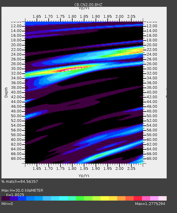
| Estimated Moho Depth: |
30.0 km |
| Estimated Crust Vp/Vs: |
1.80 |
| Assumed Crust Vp: |
6.459 km/s |
| Estimated Crust Vs: |
3.584 km/s |
| Estimated Crust Poisson's Ratio: |
0.28 |
|
| Radial Match: |
94.56357 % |
| Radial Bump: |
255 |
| Transverse Match: |
81.11075 % |
| Transverse Bump: |
400 |
| SOD ConfigId: |
13570011 |
| Insert Time: |
2019-04-30 18:47:33.416 +0000 |
| GWidth: |
2.5 |
| Max Bumps: |
400 |
| Tol: |
0.001 |
|

Signal To Noise
| Channel | StoN | STA | LTA |
| CB:CN2:00:BHZ:20180812T15:07:17.939992Z | 5.935153 | 8.6910165E-7 | 1.464329E-7 |
| CB:CN2:00:BHN:20180812T15:07:17.939992Z | 5.2624016 | 3.8947752E-7 | 7.401136E-8 |
| CB:CN2:00:BHE:20180812T15:07:17.939992Z | 1.8247842 | 2.4039298E-7 | 1.3173775E-7 |
| Arrivals |
| Ps | 3.9 SECOND |
| PpPs | 12 SECOND |
| PsPs/PpSs | 16 SECOND |


