You are here: Home > Network List > TA - USArray Transportable Network (new EarthScope stations) Stations List
> Station X20A Quemado, NM, USA > Earthquake Result Viewer
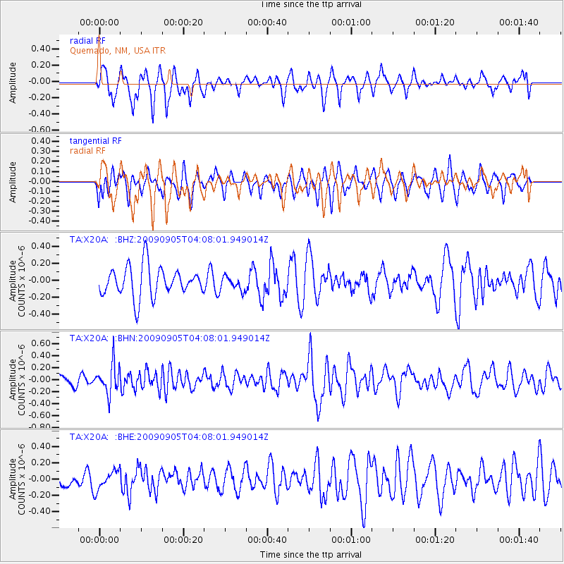
X20A Quemado, NM, USA - Earthquake Result Viewer
*The percent match for this event was below the threshold and hence no stack was calculated.
| Earthquake location: |
Southern Peru |
| Earthquake latitude/longitude: |
-15.1/-70.2 |
| Earthquake time(UTC): |
2009/09/05 (248) 03:58:39 GMT |
| Earthquake Depth: |
210 km |
| Earthquake Magnitude: |
5.8 MW, 5.2 MB, 5.8 MW |
| Earthquake Catalog/Contributor: |
WHDF/NEIC |
|
| Network: |
TA USArray Transportable Network (new EarthScope stations) |
| Station: |
X20A Quemado, NM, USA |
| Lat/Lon: |
34.54 N/108.50 W |
| Elevation: |
2057 m |
|
| Distance: |
61.3 deg |
| Az: |
324.375 deg |
| Baz: |
137.04 deg |
| Ray Param: |
$rayparam |
*The percent match for this event was below the threshold and hence was not used in the summary stack. |
|
| Radial Match: |
79.4321 % |
| Radial Bump: |
400 |
| Transverse Match: |
48.88146 % |
| Transverse Bump: |
370 |
| SOD ConfigId: |
2622 |
| Insert Time: |
2010-03-06 13:44:38.685 +0000 |
| GWidth: |
2.5 |
| Max Bumps: |
400 |
| Tol: |
0.001 |
|
Signal To Noise
| Channel | StoN | STA | LTA |
| TA:X20A: :BHN:20090905T04:08:01.949014Z | 3.371136 | 2.4953079E-7 | 7.40198E-8 |
| TA:X20A: :BHE:20090905T04:08:01.949014Z | 0.7713729 | 1.0953384E-7 | 1.4199856E-7 |
| TA:X20A: :BHZ:20090905T04:08:01.949014Z | 0.45322266 | 8.034565E-8 | 1.7727633E-7 |
| Arrivals |
| Ps | |
| PpPs | |
| PsPs/PpSs | |


