You are here: Home > Network List > TA - USArray Transportable Network (new EarthScope stations) Stations List
> Station X20A Quemado, NM, USA > Earthquake Result Viewer
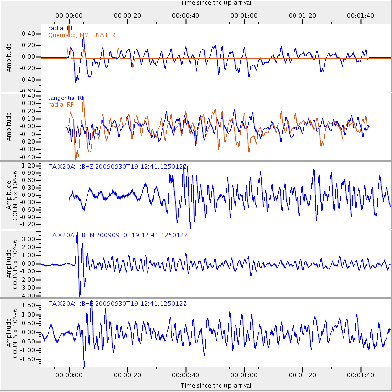
X20A Quemado, NM, USA - Earthquake Result Viewer
*The percent match for this event was below the threshold and hence no stack was calculated.
| Earthquake location: |
Peru-Bolivia Border Region |
| Earthquake latitude/longitude: |
-15.6/-69.3 |
| Earthquake time(UTC): |
2009/09/30 (273) 19:03:17 GMT |
| Earthquake Depth: |
255 km |
| Earthquake Magnitude: |
5.9 MB, 5.8 MW |
| Earthquake Catalog/Contributor: |
WHDF/NEIC |
|
| Network: |
TA USArray Transportable Network (new EarthScope stations) |
| Station: |
X20A Quemado, NM, USA |
| Lat/Lon: |
34.54 N/108.50 W |
| Elevation: |
2057 m |
|
| Distance: |
62.2 deg |
| Az: |
323.858 deg |
| Baz: |
136.477 deg |
| Ray Param: |
$rayparam |
*The percent match for this event was below the threshold and hence was not used in the summary stack. |
|
| Radial Match: |
65.339455 % |
| Radial Bump: |
400 |
| Transverse Match: |
66.1945 % |
| Transverse Bump: |
400 |
| SOD ConfigId: |
2622 |
| Insert Time: |
2010-03-06 13:44:45.232 +0000 |
| GWidth: |
2.5 |
| Max Bumps: |
400 |
| Tol: |
0.001 |
|
Signal To Noise
| Channel | StoN | STA | LTA |
| TA:X20A: :BHN:20090930T19:12:41.125012Z | 22.028862 | 1.7617347E-6 | 7.997394E-8 |
| TA:X20A: :BHE:20090930T19:12:41.125012Z | 1.0860603 | 2.5025292E-7 | 2.3042267E-7 |
| TA:X20A: :BHZ:20090930T19:12:41.125012Z | 2.4228826 | 3.979998E-7 | 1.6426706E-7 |
| Arrivals |
| Ps | |
| PpPs | |
| PsPs/PpSs | |


