You are here: Home > Network List > CI - Caltech Regional Seismic Network Stations List
> Station PHL Parkhill, California, USA > Earthquake Result Viewer
PHL Parkhill, California, USA - Earthquake Result Viewer
| Earthquake location: |
Near Coast Of Northern Chile |
| Earthquake latitude/longitude: |
-23.9/-70.2 |
| Earthquake time(UTC): |
1998/01/30 (030) 12:16:08 GMT |
| Earthquake Depth: |
42 km |
| Earthquake Magnitude: |
6.3 MB, 6.5 MS, 7.0 UNKNOWN, 6.7 ME |
| Earthquake Catalog/Contributor: |
WHDF/NEIC |
|
| Network: |
CI Caltech Regional Seismic Network |
| Station: |
PHL Parkhill, California, USA |
| Lat/Lon: |
35.41 N/120.55 W |
| Elevation: |
351 m |
|
| Distance: |
75.8 deg |
| Az: |
319.567 deg |
| Baz: |
133.398 deg |
| Ray Param: |
0.051326722 |
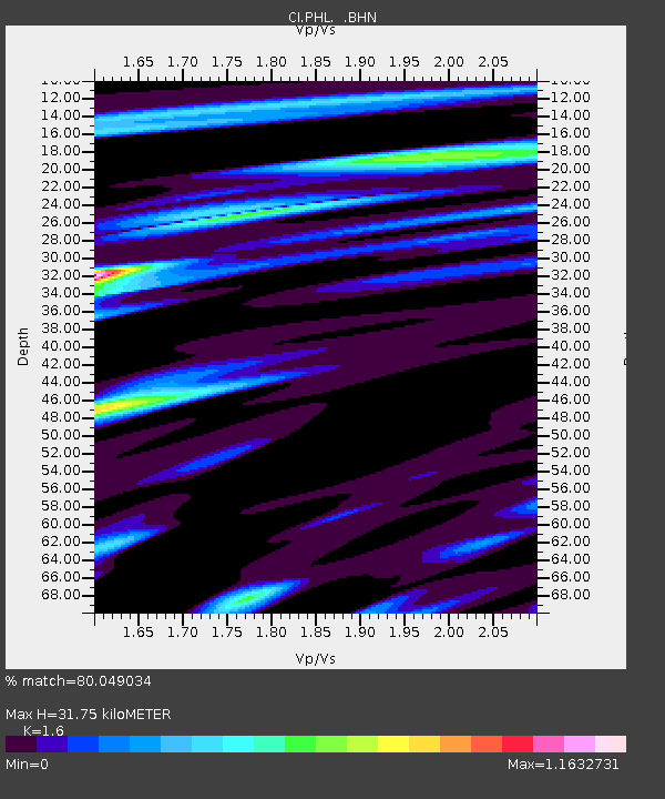
| Estimated Moho Depth: |
31.75 km |
| Estimated Crust Vp/Vs: |
1.60 |
| Assumed Crust Vp: |
6.183 km/s |
| Estimated Crust Vs: |
3.864 km/s |
| Estimated Crust Poisson's Ratio: |
0.18 |
|
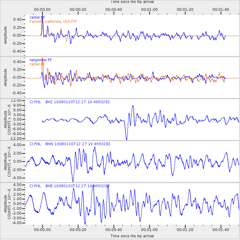
| Radial Match: |
80.049034 % |
| Radial Bump: |
400 |
| Transverse Match: |
72.94697 % |
| Transverse Bump: |
400 |
| SOD ConfigId: |
3787 |
| Insert Time: |
2010-02-26 02:11:07.882 +0000 |
| GWidth: |
2.5 |
| Max Bumps: |
400 |
| Tol: |
0.001 |
|
Signal To Noise
| Channel | StoN | STA | LTA |
| CI:PHL: :BHN:19980130T12:27:19.466028Z | 0.69732374 | 4.846877E-7 | 6.950684E-7 |
| CI:PHL: :BHE:19980130T12:27:19.466028Z | 1.3718046 | 1.3876806E-6 | 1.0115731E-6 |
| CI:PHL: :BHZ:19980130T12:27:19.466028Z | 2.3172011 | 1.6982797E-6 | 7.329013E-7 |
| Arrivals |
| Ps | 3.2 SECOND |
| PpPs | 13 SECOND |
| PsPs/PpSs | 16 SECOND |


