You are here: Home > Network List > TA - USArray Transportable Network (new EarthScope stations) Stations List
> Station X20A Quemado, NM, USA > Earthquake Result Viewer
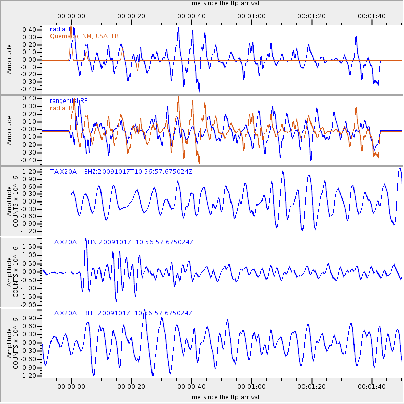
X20A Quemado, NM, USA - Earthquake Result Viewer
*The percent match for this event was below the threshold and hence no stack was calculated.
| Earthquake location: |
Samoa Islands Region |
| Earthquake latitude/longitude: |
-16.4/-172.0 |
| Earthquake time(UTC): |
2009/10/17 (290) 10:45:26 GMT |
| Earthquake Depth: |
10 km |
| Earthquake Magnitude: |
5.7 MB, 5.3 MS, 5.7 MW, 5.7 MW |
| Earthquake Catalog/Contributor: |
WHDF/NEIC |
|
| Network: |
TA USArray Transportable Network (new EarthScope stations) |
| Station: |
X20A Quemado, NM, USA |
| Lat/Lon: |
34.54 N/108.50 W |
| Elevation: |
2057 m |
|
| Distance: |
78.7 deg |
| Az: |
48.872 deg |
| Baz: |
241.162 deg |
| Ray Param: |
$rayparam |
*The percent match for this event was below the threshold and hence was not used in the summary stack. |
|
| Radial Match: |
55.229927 % |
| Radial Bump: |
356 |
| Transverse Match: |
54.302917 % |
| Transverse Bump: |
396 |
| SOD ConfigId: |
2622 |
| Insert Time: |
2010-03-06 13:44:56.386 +0000 |
| GWidth: |
2.5 |
| Max Bumps: |
400 |
| Tol: |
0.001 |
|
Signal To Noise
| Channel | StoN | STA | LTA |
| TA:X20A: :BHN:20091017T10:56:57.675024Z | 4.1050143 | 6.2098104E-7 | 1.5127378E-7 |
| TA:X20A: :BHE:20091017T10:56:57.675024Z | 0.5936871 | 2.3972532E-7 | 4.037907E-7 |
| TA:X20A: :BHZ:20091017T10:56:57.675024Z | 0.70696807 | 2.4771225E-7 | 3.5038676E-7 |
| Arrivals |
| Ps | |
| PpPs | |
| PsPs/PpSs | |


