You are here: Home > Network List > TA - USArray Transportable Network (new EarthScope stations) Stations List
> Station X20A Quemado, NM, USA > Earthquake Result Viewer
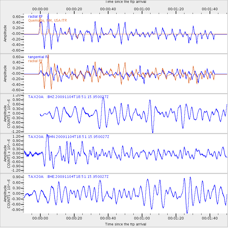
X20A Quemado, NM, USA - Earthquake Result Viewer
*The percent match for this event was below the threshold and hence no stack was calculated.
| Earthquake location: |
Azores Islands Region |
| Earthquake latitude/longitude: |
36.2/-33.9 |
| Earthquake time(UTC): |
2009/11/04 (308) 18:41:44 GMT |
| Earthquake Depth: |
10 km |
| Earthquake Magnitude: |
5.7 MB, 5.6 MS, 5.9 MW, 5.8 MW |
| Earthquake Catalog/Contributor: |
WHDF/NEIC |
|
| Network: |
TA USArray Transportable Network (new EarthScope stations) |
| Station: |
X20A Quemado, NM, USA |
| Lat/Lon: |
34.54 N/108.50 W |
| Elevation: |
2057 m |
|
| Distance: |
59.4 deg |
| Az: |
292.411 deg |
| Baz: |
65.008 deg |
| Ray Param: |
$rayparam |
*The percent match for this event was below the threshold and hence was not used in the summary stack. |
|
| Radial Match: |
71.53122 % |
| Radial Bump: |
376 |
| Transverse Match: |
70.199745 % |
| Transverse Bump: |
367 |
| SOD ConfigId: |
2622 |
| Insert Time: |
2010-03-06 13:44:57.885 +0000 |
| GWidth: |
2.5 |
| Max Bumps: |
400 |
| Tol: |
0.001 |
|
Signal To Noise
| Channel | StoN | STA | LTA |
| TA:X20A: :BHN:20091104T18:51:15.950027Z | 6.4848275 | 6.729479E-7 | 1.0377268E-7 |
| TA:X20A: :BHE:20091104T18:51:15.950027Z | 1.1250277 | 2.719464E-7 | 2.417242E-7 |
| TA:X20A: :BHZ:20091104T18:51:15.950027Z | 1.2337857 | 3.2762495E-7 | 2.6554443E-7 |
| Arrivals |
| Ps | |
| PpPs | |
| PsPs/PpSs | |


