You are here: Home > Network List > LD - Lamont-Doherty Cooperative Seismographic Network Stations List
> Station UNH University of New Hampshire, Durham, NH, USA > Earthquake Result Viewer
UNH University of New Hampshire, Durham, NH, USA - Earthquake Result Viewer
| Earthquake location: |
Northern Alaska |
| Earthquake latitude/longitude: |
69.6/-145.3 |
| Earthquake time(UTC): |
2018/08/12 (224) 14:58:54 GMT |
| Earthquake Depth: |
2.2 km |
| Earthquake Magnitude: |
6.3 ml |
| Earthquake Catalog/Contributor: |
NEIC PDE/ak |
|
| Network: |
LD Lamont-Doherty Cooperative Seismographic Network |
| Station: |
UNH University of New Hampshire, Durham, NH, USA |
| Lat/Lon: |
43.09 N/70.87 W |
| Elevation: |
5.0 m |
|
| Distance: |
45.1 deg |
| Az: |
85.537 deg |
| Baz: |
331.441 deg |
| Ray Param: |
0.0715505 |
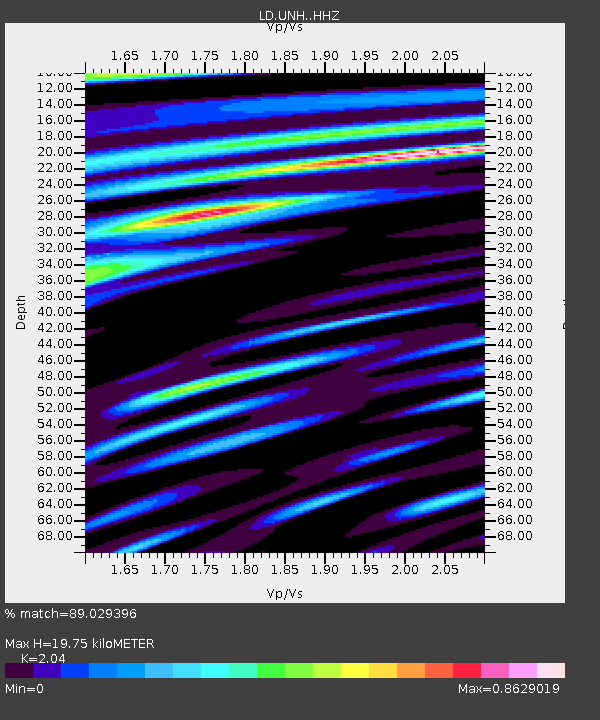
| Estimated Moho Depth: |
19.75 km |
| Estimated Crust Vp/Vs: |
2.04 |
| Assumed Crust Vp: |
6.419 km/s |
| Estimated Crust Vs: |
3.147 km/s |
| Estimated Crust Poisson's Ratio: |
0.34 |
|
| Radial Match: |
89.029396 % |
| Radial Bump: |
345 |
| Transverse Match: |
73.442726 % |
| Transverse Bump: |
400 |
| SOD ConfigId: |
13570011 |
| Insert Time: |
2019-04-30 18:51:35.934 +0000 |
| GWidth: |
2.5 |
| Max Bumps: |
400 |
| Tol: |
0.001 |
|

Signal To Noise
| Channel | StoN | STA | LTA |
| LD:UNH: :HHZ:20180812T15:06:40.525014Z | 10.715367 | 1.2950409E-6 | 1.2085827E-7 |
| LD:UNH: :HHN:20180812T15:06:40.525014Z | 7.738184 | 5.8844654E-7 | 7.604453E-8 |
| LD:UNH: :HHE:20180812T15:06:40.525014Z | 3.5958982 | 4.4437814E-7 | 1.2357918E-7 |
| Arrivals |
| Ps | 3.4 SECOND |
| PpPs | 8.8 SECOND |
| PsPs/PpSs | 12 SECOND |


