You are here: Home > Network List > MM - Myanmar National Seismic Network Stations List
> Station HKA Haka, Chin, Myanmar > Earthquake Result Viewer
HKA Haka, Chin, Myanmar - Earthquake Result Viewer
| Earthquake location: |
Northern Alaska |
| Earthquake latitude/longitude: |
69.6/-145.3 |
| Earthquake time(UTC): |
2018/08/12 (224) 14:58:54 GMT |
| Earthquake Depth: |
2.2 km |
| Earthquake Magnitude: |
6.3 ml |
| Earthquake Catalog/Contributor: |
NEIC PDE/ak |
|
| Network: |
MM Myanmar National Seismic Network |
| Station: |
HKA Haka, Chin, Myanmar |
| Lat/Lon: |
22.64 N/93.60 E |
| Elevation: |
1733 m |
|
| Distance: |
79.0 deg |
| Az: |
306.308 deg |
| Baz: |
17.842 deg |
| Ray Param: |
0.0492731 |
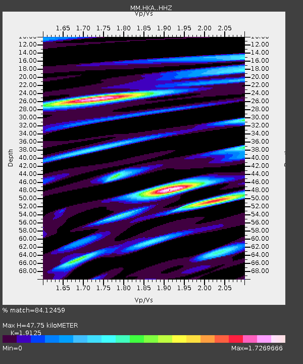
| Estimated Moho Depth: |
47.75 km |
| Estimated Crust Vp/Vs: |
1.91 |
| Assumed Crust Vp: |
6.552 km/s |
| Estimated Crust Vs: |
3.426 km/s |
| Estimated Crust Poisson's Ratio: |
0.31 |
|
| Radial Match: |
84.12459 % |
| Radial Bump: |
400 |
| Transverse Match: |
87.81726 % |
| Transverse Bump: |
400 |
| SOD ConfigId: |
13570011 |
| Insert Time: |
2019-04-30 18:51:44.029 +0000 |
| GWidth: |
2.5 |
| Max Bumps: |
400 |
| Tol: |
0.001 |
|

Signal To Noise
| Channel | StoN | STA | LTA |
| MM:HKA: :HHZ:20180812T15:10:28.178029Z | 3.6676016 | 4.449419E-7 | 1.2131686E-7 |
| MM:HKA: :HHN:20180812T15:10:28.178029Z | 1.3974925 | 2.9653773E-7 | 2.121927E-7 |
| MM:HKA: :HHE:20180812T15:10:28.178029Z | 0.86182964 | 1.6148765E-7 | 1.873777E-7 |
| Arrivals |
| Ps | 6.8 SECOND |
| PpPs | 21 SECOND |
| PsPs/PpSs | 27 SECOND |


