You are here: Home > Network List > TA - USArray Transportable Network (new EarthScope stations) Stations List
> Station X20A Quemado, NM, USA > Earthquake Result Viewer
X20A Quemado, NM, USA - Earthquake Result Viewer
*The percent match for this event was below the threshold and hence no stack was calculated.
| Earthquake location: |
Mariana Islands |
| Earthquake latitude/longitude: |
19.1/145.8 |
| Earthquake time(UTC): |
2008/12/02 (337) 12:31:43 GMT |
| Earthquake Depth: |
137 km |
| Earthquake Magnitude: |
5.9 MB, 5.9 MW, 5.9 MW |
| Earthquake Catalog/Contributor: |
WHDF/NEIC |
|
| Network: |
TA USArray Transportable Network (new EarthScope stations) |
| Station: |
X20A Quemado, NM, USA |
| Lat/Lon: |
34.54 N/108.50 W |
| Elevation: |
2057 m |
|
| Distance: |
91.6 deg |
| Az: |
52.636 deg |
| Baz: |
294.435 deg |
| Ray Param: |
$rayparam |
*The percent match for this event was below the threshold and hence was not used in the summary stack. |
|
| Radial Match: |
58.94683 % |
| Radial Bump: |
295 |
| Transverse Match: |
43.962494 % |
| Transverse Bump: |
371 |
| SOD ConfigId: |
2658 |
| Insert Time: |
2010-03-06 13:45:04.374 +0000 |
| GWidth: |
2.5 |
| Max Bumps: |
400 |
| Tol: |
0.001 |
|
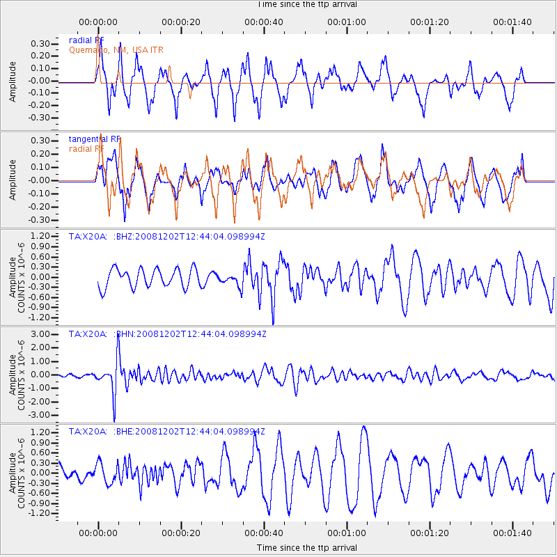
Signal To Noise
| Channel | StoN | STA | LTA |
| TA:X20A: :BHN:20081202T12:44:04.098994Z | 12.270822 | 1.2290144E-6 | 1.0015746E-7 |
| TA:X20A: :BHE:20081202T12:44:04.098994Z | 1.0233818 | 3.068405E-7 | 2.998299E-7 |
| TA:X20A: :BHZ:20081202T12:44:04.098994Z | 0.72015697 | 1.9361364E-7 | 2.6884922E-7 |
| Arrivals |
| Ps | |
| PpPs | |
| PsPs/PpSs | |


