You are here: Home > Network List > TA - USArray Transportable Network (new EarthScope stations) Stations List
> Station X20A Quemado, NM, USA > Earthquake Result Viewer
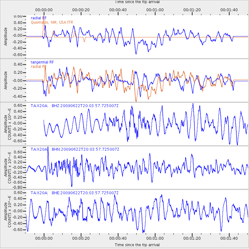
X20A Quemado, NM, USA - Earthquake Result Viewer
*The percent match for this event was below the threshold and hence no stack was calculated.
| Earthquake location: |
Andreanof Islands, Aleutian Is. |
| Earthquake latitude/longitude: |
51.3/-178.2 |
| Earthquake time(UTC): |
2009/06/22 (173) 19:55:24 GMT |
| Earthquake Depth: |
35 km |
| Earthquake Magnitude: |
5.6 MB, 5.6 MW, 5.6 MW |
| Earthquake Catalog/Contributor: |
WHDF/NEIC |
|
| Network: |
TA USArray Transportable Network (new EarthScope stations) |
| Station: |
X20A Quemado, NM, USA |
| Lat/Lon: |
34.54 N/108.50 W |
| Elevation: |
2057 m |
|
| Distance: |
51.8 deg |
| Az: |
80.345 deg |
| Baz: |
311.399 deg |
| Ray Param: |
$rayparam |
*The percent match for this event was below the threshold and hence was not used in the summary stack. |
|
| Radial Match: |
49.57243 % |
| Radial Bump: |
400 |
| Transverse Match: |
53.896275 % |
| Transverse Bump: |
400 |
| SOD ConfigId: |
2648 |
| Insert Time: |
2010-03-06 13:45:19.544 +0000 |
| GWidth: |
2.5 |
| Max Bumps: |
400 |
| Tol: |
0.001 |
|
Signal To Noise
| Channel | StoN | STA | LTA |
| TA:X20A: :BHN:20090622T20:03:57.725007Z | 2.8726416 | 2.6059817E-7 | 9.071726E-8 |
| TA:X20A: :BHE:20090622T20:03:57.725007Z | 1.099029 | 3.3645873E-7 | 3.0614183E-7 |
| TA:X20A: :BHZ:20090622T20:03:57.725007Z | 0.80259377 | 1.8656372E-7 | 2.32451E-7 |
| Arrivals |
| Ps | |
| PpPs | |
| PsPs/PpSs | |


