You are here: Home > Network List > N4 - Central and EAstern US Network Stations List
> Station K43A Burlington, WI, USA > Earthquake Result Viewer
K43A Burlington, WI, USA - Earthquake Result Viewer
| Earthquake location: |
Northern Alaska |
| Earthquake latitude/longitude: |
69.6/-145.3 |
| Earthquake time(UTC): |
2018/08/12 (224) 14:58:54 GMT |
| Earthquake Depth: |
2.2 km |
| Earthquake Magnitude: |
6.3 ml |
| Earthquake Catalog/Contributor: |
NEIC PDE/ak |
|
| Network: |
N4 Central and EAstern US Network |
| Station: |
K43A Burlington, WI, USA |
| Lat/Lon: |
42.70 N/88.33 W |
| Elevation: |
264 m |
|
| Distance: |
39.3 deg |
| Az: |
102.663 deg |
| Baz: |
332.294 deg |
| Ray Param: |
0.07508331 |
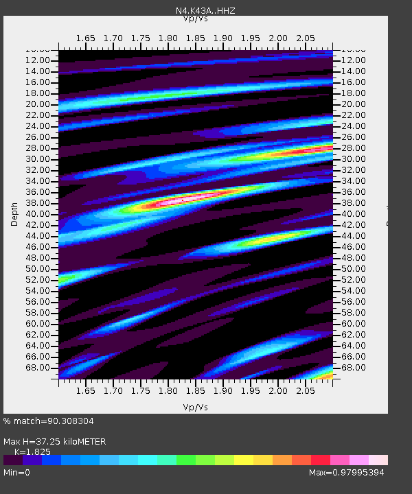
| Estimated Moho Depth: |
37.25 km |
| Estimated Crust Vp/Vs: |
1.83 |
| Assumed Crust Vp: |
6.571 km/s |
| Estimated Crust Vs: |
3.6 km/s |
| Estimated Crust Poisson's Ratio: |
0.29 |
|
| Radial Match: |
90.308304 % |
| Radial Bump: |
294 |
| Transverse Match: |
82.111984 % |
| Transverse Bump: |
310 |
| SOD ConfigId: |
13570011 |
| Insert Time: |
2019-04-30 18:52:31.881 +0000 |
| GWidth: |
2.5 |
| Max Bumps: |
400 |
| Tol: |
0.001 |
|

Signal To Noise
| Channel | StoN | STA | LTA |
| N4:K43A: :HHZ:20180812T15:05:53.640004Z | 25.208828 | 2.3553653E-6 | 9.3434146E-8 |
| N4:K43A: :HHN:20180812T15:05:53.640004Z | 16.836441 | 1.1781192E-6 | 6.9974355E-8 |
| N4:K43A: :HHE:20180812T15:05:53.640004Z | 7.242839 | 6.6376816E-7 | 9.164475E-8 |
| Arrivals |
| Ps | 5.0 SECOND |
| PpPs | 15 SECOND |
| PsPs/PpSs | 20 SECOND |


