You are here: Home > Network List > TA - USArray Transportable Network (new EarthScope stations) Stations List
> Station X20A Quemado, NM, USA > Earthquake Result Viewer
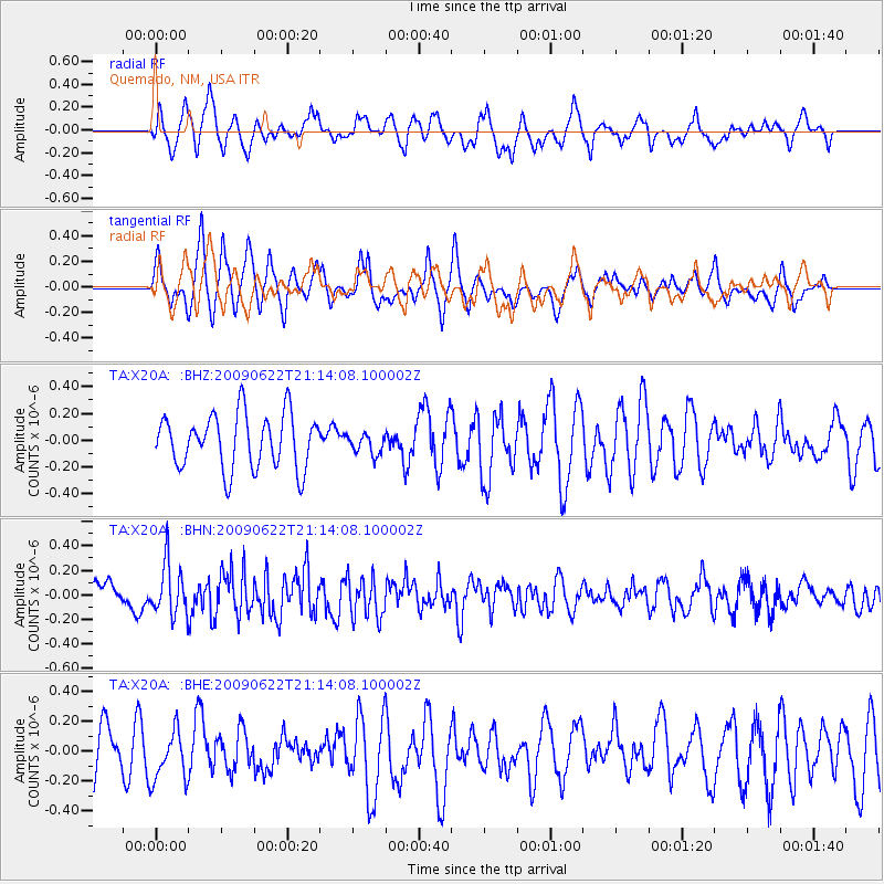
X20A Quemado, NM, USA - Earthquake Result Viewer
*The percent match for this event was below the threshold and hence no stack was calculated.
| Earthquake location: |
Andreanof Islands, Aleutian Is. |
| Earthquake latitude/longitude: |
51.3/-178.2 |
| Earthquake time(UTC): |
2009/06/22 (173) 21:05:33 GMT |
| Earthquake Depth: |
29 km |
| Earthquake Magnitude: |
5.5 MB, 5.0 MS, 5.4 MW, 5.4 MW |
| Earthquake Catalog/Contributor: |
WHDF/NEIC |
|
| Network: |
TA USArray Transportable Network (new EarthScope stations) |
| Station: |
X20A Quemado, NM, USA |
| Lat/Lon: |
34.54 N/108.50 W |
| Elevation: |
2057 m |
|
| Distance: |
51.8 deg |
| Az: |
80.366 deg |
| Baz: |
311.492 deg |
| Ray Param: |
$rayparam |
*The percent match for this event was below the threshold and hence was not used in the summary stack. |
|
| Radial Match: |
34.12278 % |
| Radial Bump: |
280 |
| Transverse Match: |
51.51776 % |
| Transverse Bump: |
304 |
| SOD ConfigId: |
2648 |
| Insert Time: |
2010-03-06 13:45:21.601 +0000 |
| GWidth: |
2.5 |
| Max Bumps: |
400 |
| Tol: |
0.001 |
|
Signal To Noise
| Channel | StoN | STA | LTA |
| TA:X20A: :BHN:20090622T21:14:08.100002Z | 2.9235327 | 2.0677906E-7 | 7.072917E-8 |
| TA:X20A: :BHE:20090622T21:14:08.100002Z | 1.0816673 | 1.6717657E-7 | 1.5455451E-7 |
| TA:X20A: :BHZ:20090622T21:14:08.100002Z | 0.37374946 | 7.554668E-8 | 2.0213186E-7 |
| Arrivals |
| Ps | |
| PpPs | |
| PsPs/PpSs | |


