You are here: Home > Network List > N4 - Central and EAstern US Network Stations List
> Station P38B Dawn, MO, USA > Earthquake Result Viewer
P38B Dawn, MO, USA - Earthquake Result Viewer
| Earthquake location: |
Northern Alaska |
| Earthquake latitude/longitude: |
69.6/-145.3 |
| Earthquake time(UTC): |
2018/08/12 (224) 14:58:54 GMT |
| Earthquake Depth: |
2.2 km |
| Earthquake Magnitude: |
6.3 ml |
| Earthquake Catalog/Contributor: |
NEIC PDE/ak |
|
| Network: |
N4 Central and EAstern US Network |
| Station: |
P38B Dawn, MO, USA |
| Lat/Lon: |
39.62 N/93.53 W |
| Elevation: |
248 m |
|
| Distance: |
40.3 deg |
| Az: |
110.297 deg |
| Baz: |
334.75 deg |
| Ray Param: |
0.074492626 |
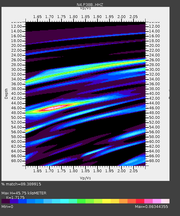
| Estimated Moho Depth: |
45.75 km |
| Estimated Crust Vp/Vs: |
1.72 |
| Assumed Crust Vp: |
6.498 km/s |
| Estimated Crust Vs: |
3.783 km/s |
| Estimated Crust Poisson's Ratio: |
0.24 |
|
| Radial Match: |
89.389915 % |
| Radial Bump: |
258 |
| Transverse Match: |
74.14147 % |
| Transverse Bump: |
400 |
| SOD ConfigId: |
13570011 |
| Insert Time: |
2019-04-30 18:52:54.412 +0000 |
| GWidth: |
2.5 |
| Max Bumps: |
400 |
| Tol: |
0.001 |
|

Signal To Noise
| Channel | StoN | STA | LTA |
| N4:P38B: :HHZ:20180812T15:06:01.96999Z | 23.268589 | 1.7317004E-6 | 7.442223E-8 |
| N4:P38B: :HHN:20180812T15:06:01.96999Z | 13.177015 | 1.0369542E-6 | 7.869417E-8 |
| N4:P38B: :HHE:20180812T15:06:01.96999Z | 7.254331 | 4.0970932E-7 | 5.647789E-8 |
| Arrivals |
| Ps | 5.4 SECOND |
| PpPs | 18 SECOND |
| PsPs/PpSs | 23 SECOND |


