You are here: Home > Network List > CI - Caltech Regional Seismic Network Stations List
> Station PHL Parkhill, California, USA > Earthquake Result Viewer
PHL Parkhill, California, USA - Earthquake Result Viewer
| Earthquake location: |
South Of Fiji Islands |
| Earthquake latitude/longitude: |
-22.2/-179.5 |
| Earthquake time(UTC): |
1998/05/16 (136) 02:22:03 GMT |
| Earthquake Depth: |
586 km |
| Earthquake Magnitude: |
6.1 MB, 6.8 UNKNOWN |
| Earthquake Catalog/Contributor: |
WHDF/NEIC |
|
| Network: |
CI Caltech Regional Seismic Network |
| Station: |
PHL Parkhill, California, USA |
| Lat/Lon: |
35.41 N/120.55 W |
| Elevation: |
351 m |
|
| Distance: |
80.0 deg |
| Az: |
45.296 deg |
| Baz: |
233.726 deg |
| Ray Param: |
0.04675716 |
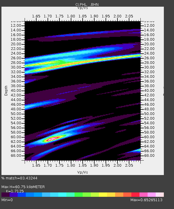
| Estimated Moho Depth: |
60.75 km |
| Estimated Crust Vp/Vs: |
1.71 |
| Assumed Crust Vp: |
6.183 km/s |
| Estimated Crust Vs: |
3.61 km/s |
| Estimated Crust Poisson's Ratio: |
0.24 |
|
| Radial Match: |
83.43244 % |
| Radial Bump: |
400 |
| Transverse Match: |
76.26913 % |
| Transverse Bump: |
400 |
| SOD ConfigId: |
3787 |
| Insert Time: |
2010-02-26 02:11:10.661 +0000 |
| GWidth: |
2.5 |
| Max Bumps: |
400 |
| Tol: |
0.001 |
|

Signal To Noise
| Channel | StoN | STA | LTA |
| CI:PHL: :BHN:19980516T02:32:41.465015Z | 1.0162102 | 1.8477402E-7 | 1.8182658E-7 |
| CI:PHL: :BHE:19980516T02:32:41.465015Z | 1.420087 | 3.688179E-7 | 2.59715E-7 |
| CI:PHL: :BHZ:19980516T02:32:41.465015Z | 3.0561967 | 8.243648E-7 | 2.6973552E-7 |
| Arrivals |
| Ps | 7.2 SECOND |
| PpPs | 26 SECOND |
| PsPs/PpSs | 33 SECOND |


