You are here: Home > Network List > N4 - Central and EAstern US Network Stations List
> Station Q44B Vandalia, IL, USA > Earthquake Result Viewer
Q44B Vandalia, IL, USA - Earthquake Result Viewer
| Earthquake location: |
Northern Alaska |
| Earthquake latitude/longitude: |
69.6/-145.3 |
| Earthquake time(UTC): |
2018/08/12 (224) 14:58:54 GMT |
| Earthquake Depth: |
2.2 km |
| Earthquake Magnitude: |
6.3 ml |
| Earthquake Catalog/Contributor: |
NEIC PDE/ak |
|
| Network: |
N4 Central and EAstern US Network |
| Station: |
Q44B Vandalia, IL, USA |
| Lat/Lon: |
38.90 N/89.02 W |
| Elevation: |
168 m |
|
| Distance: |
42.5 deg |
| Az: |
105.977 deg |
| Baz: |
334.355 deg |
| Ray Param: |
0.073180266 |
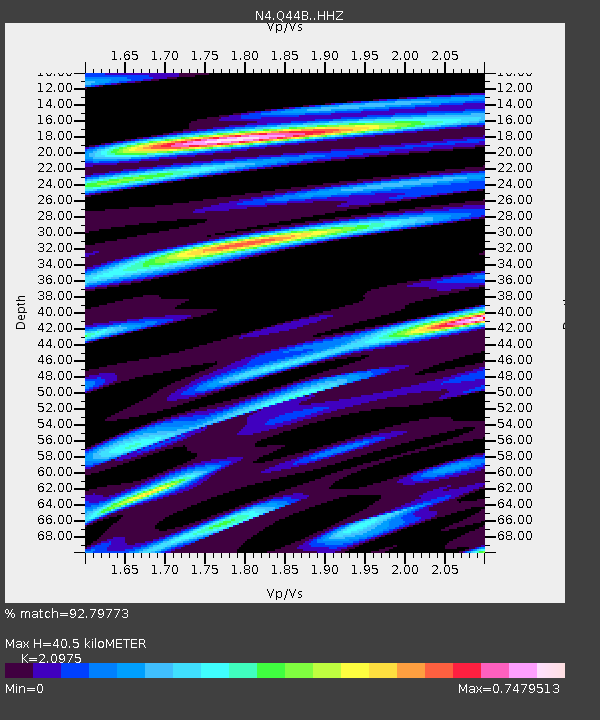
| Estimated Moho Depth: |
40.5 km |
| Estimated Crust Vp/Vs: |
2.10 |
| Assumed Crust Vp: |
6.444 km/s |
| Estimated Crust Vs: |
3.072 km/s |
| Estimated Crust Poisson's Ratio: |
0.35 |
|
| Radial Match: |
92.79773 % |
| Radial Bump: |
261 |
| Transverse Match: |
77.152626 % |
| Transverse Bump: |
400 |
| SOD ConfigId: |
13570011 |
| Insert Time: |
2019-04-30 18:53:00.560 +0000 |
| GWidth: |
2.5 |
| Max Bumps: |
400 |
| Tol: |
0.001 |
|

Signal To Noise
| Channel | StoN | STA | LTA |
| N4:Q44B: :HHZ:20180812T15:06:19.670003Z | 36.678013 | 3.1851334E-6 | 8.684041E-8 |
| N4:Q44B: :HHN:20180812T15:06:19.670003Z | 9.65555 | 1.422767E-6 | 1.4735224E-7 |
| N4:Q44B: :HHE:20180812T15:06:19.670003Z | 9.536591 | 8.104755E-7 | 8.498587E-8 |
| Arrivals |
| Ps | 7.3 SECOND |
| PpPs | 18 SECOND |
| PsPs/PpSs | 26 SECOND |


