You are here: Home > Network List > TA - USArray Transportable Network (new EarthScope stations) Stations List
> Station X20A Quemado, NM, USA > Earthquake Result Viewer
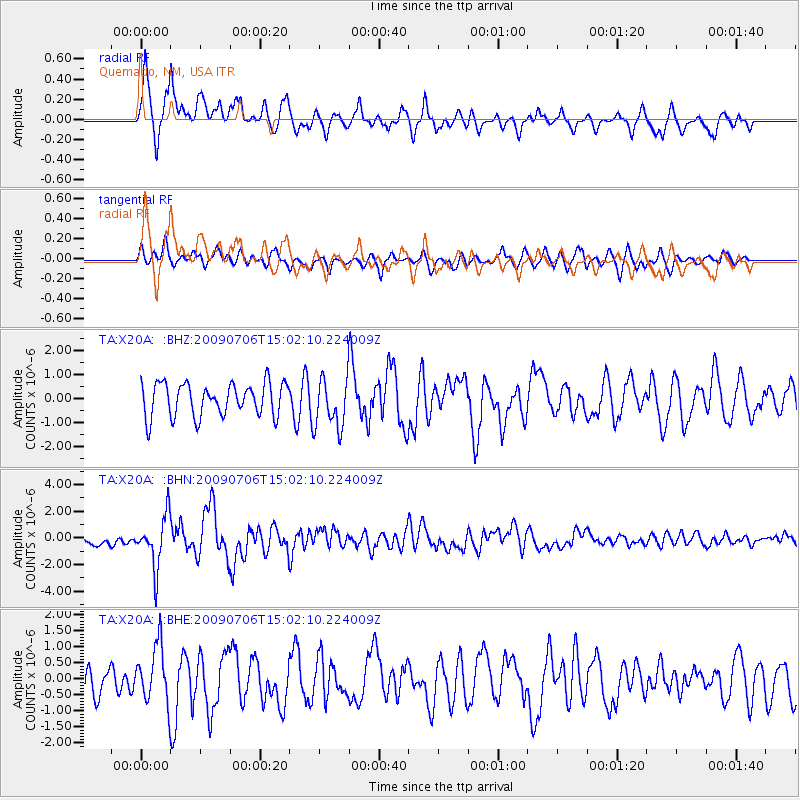
X20A Quemado, NM, USA - Earthquake Result Viewer
*The percent match for this event was below the threshold and hence no stack was calculated.
| Earthquake location: |
Rat Islands, Aleutian Islands |
| Earthquake latitude/longitude: |
50.4/177.0 |
| Earthquake time(UTC): |
2009/07/06 (187) 14:53:12 GMT |
| Earthquake Depth: |
22 km |
| Earthquake Magnitude: |
6.0 MB, 5.8 MS, 6.1 MW, 6.0 MW |
| Earthquake Catalog/Contributor: |
WHDF/NEIC |
|
| Network: |
TA USArray Transportable Network (new EarthScope stations) |
| Station: |
X20A Quemado, NM, USA |
| Lat/Lon: |
34.54 N/108.50 W |
| Elevation: |
2057 m |
|
| Distance: |
54.9 deg |
| Az: |
76.468 deg |
| Baz: |
311.133 deg |
| Ray Param: |
$rayparam |
*The percent match for this event was below the threshold and hence was not used in the summary stack. |
|
| Radial Match: |
76.65702 % |
| Radial Bump: |
400 |
| Transverse Match: |
53.96596 % |
| Transverse Bump: |
400 |
| SOD ConfigId: |
2648 |
| Insert Time: |
2010-03-06 13:45:26.864 +0000 |
| GWidth: |
2.5 |
| Max Bumps: |
400 |
| Tol: |
0.001 |
|
Signal To Noise
| Channel | StoN | STA | LTA |
| TA:X20A: :BHN:20090706T15:02:10.224009Z | 4.0361204 | 1.9028164E-6 | 4.7144684E-7 |
| TA:X20A: :BHE:20090706T15:02:10.224009Z | 1.3809348 | 9.0069796E-7 | 6.522378E-7 |
| TA:X20A: :BHZ:20090706T15:02:10.224009Z | 1.5109323 | 1.0389102E-6 | 6.8759545E-7 |
| Arrivals |
| Ps | |
| PpPs | |
| PsPs/PpSs | |


