You are here: Home > Network List > N4 - Central and EAstern US Network Stations List
> Station R58B Mineral, VA, USA > Earthquake Result Viewer
R58B Mineral, VA, USA - Earthquake Result Viewer
| Earthquake location: |
Northern Alaska |
| Earthquake latitude/longitude: |
69.6/-145.3 |
| Earthquake time(UTC): |
2018/08/12 (224) 14:58:54 GMT |
| Earthquake Depth: |
2.2 km |
| Earthquake Magnitude: |
6.3 ml |
| Earthquake Catalog/Contributor: |
NEIC PDE/ak |
|
| Network: |
N4 Central and EAstern US Network |
| Station: |
R58B Mineral, VA, USA |
| Lat/Lon: |
37.96 N/77.88 W |
| Elevation: |
116 m |
|
| Distance: |
47.1 deg |
| Az: |
95.398 deg |
| Baz: |
333.741 deg |
| Ray Param: |
0.070206404 |
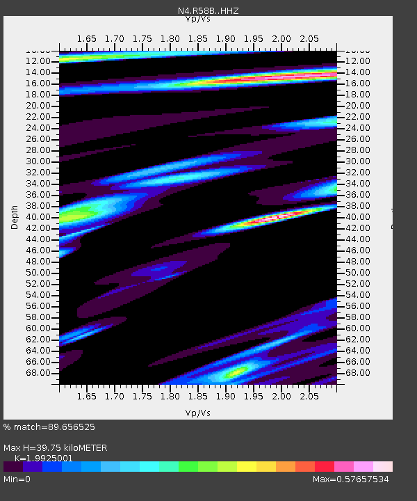
| Estimated Moho Depth: |
39.75 km |
| Estimated Crust Vp/Vs: |
1.99 |
| Assumed Crust Vp: |
6.565 km/s |
| Estimated Crust Vs: |
3.295 km/s |
| Estimated Crust Poisson's Ratio: |
0.33 |
|
| Radial Match: |
89.656525 % |
| Radial Bump: |
330 |
| Transverse Match: |
85.74844 % |
| Transverse Bump: |
400 |
| SOD ConfigId: |
13570011 |
| Insert Time: |
2019-04-30 18:53:10.362 +0000 |
| GWidth: |
2.5 |
| Max Bumps: |
400 |
| Tol: |
0.001 |
|

Signal To Noise
| Channel | StoN | STA | LTA |
| N4:R58B: :HHZ:20180812T15:06:56.939992Z | 19.867296 | 1.3469295E-6 | 6.7796314E-8 |
| N4:R58B: :HHN:20180812T15:06:56.939992Z | 8.27274 | 8.445858E-7 | 1.02092635E-7 |
| N4:R58B: :HHE:20180812T15:06:56.939992Z | 2.8558085 | 2.7190393E-7 | 9.5210844E-8 |
| Arrivals |
| Ps | 6.4 SECOND |
| PpPs | 17 SECOND |
| PsPs/PpSs | 23 SECOND |


