You are here: Home > Network List > N4 - Central and EAstern US Network Stations List
> Station T45B Paducah, KY, USA > Earthquake Result Viewer
T45B Paducah, KY, USA - Earthquake Result Viewer
| Earthquake location: |
Northern Alaska |
| Earthquake latitude/longitude: |
69.6/-145.3 |
| Earthquake time(UTC): |
2018/08/12 (224) 14:58:54 GMT |
| Earthquake Depth: |
2.2 km |
| Earthquake Magnitude: |
6.3 ml |
| Earthquake Catalog/Contributor: |
NEIC PDE/ak |
|
| Network: |
N4 Central and EAstern US Network |
| Station: |
T45B Paducah, KY, USA |
| Lat/Lon: |
37.02 N/88.65 W |
| Elevation: |
136 m |
|
| Distance: |
44.3 deg |
| Az: |
106.761 deg |
| Baz: |
335.152 deg |
| Ray Param: |
0.07202711 |
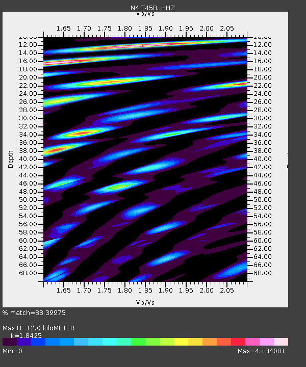
| Estimated Moho Depth: |
12.0 km |
| Estimated Crust Vp/Vs: |
1.84 |
| Assumed Crust Vp: |
6.444 km/s |
| Estimated Crust Vs: |
3.497 km/s |
| Estimated Crust Poisson's Ratio: |
0.29 |
|
| Radial Match: |
88.39975 % |
| Radial Bump: |
400 |
| Transverse Match: |
66.115204 % |
| Transverse Bump: |
400 |
| SOD ConfigId: |
13570011 |
| Insert Time: |
2019-04-30 18:53:16.857 +0000 |
| GWidth: |
2.5 |
| Max Bumps: |
400 |
| Tol: |
0.001 |
|

Signal To Noise
| Channel | StoN | STA | LTA |
| N4:T45B: :HHZ:20180812T15:06:34.409993Z | 10.770661 | 1.6118817E-6 | 1.4965485E-7 |
| N4:T45B: :HHN:20180812T15:06:34.409993Z | 9.774701 | 1.8399741E-6 | 1.882384E-7 |
| N4:T45B: :HHE:20180812T15:06:34.409993Z | 4.9050837 | 9.4551854E-7 | 1.9276297E-7 |
| Arrivals |
| Ps | 1.7 SECOND |
| PpPs | 5.0 SECOND |
| PsPs/PpSs | 6.6 SECOND |


