You are here: Home > Network List > N4 - Central and EAstern US Network Stations List
> Station T59A Double 'B' Farms, VA, USA > Earthquake Result Viewer
T59A Double 'B' Farms, VA, USA - Earthquake Result Viewer
| Earthquake location: |
Northern Alaska |
| Earthquake latitude/longitude: |
69.6/-145.3 |
| Earthquake time(UTC): |
2018/08/12 (224) 14:58:54 GMT |
| Earthquake Depth: |
2.2 km |
| Earthquake Magnitude: |
6.3 ml |
| Earthquake Catalog/Contributor: |
NEIC PDE/ak |
|
| Network: |
N4 Central and EAstern US Network |
| Station: |
T59A Double 'B' Farms, VA, USA |
| Lat/Lon: |
36.97 N/77.55 W |
| Elevation: |
63 m |
|
| Distance: |
48.1 deg |
| Az: |
95.673 deg |
| Baz: |
334.122 deg |
| Ray Param: |
0.06956382 |
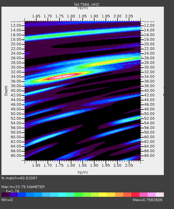
| Estimated Moho Depth: |
33.75 km |
| Estimated Crust Vp/Vs: |
1.76 |
| Assumed Crust Vp: |
6.565 km/s |
| Estimated Crust Vs: |
3.73 km/s |
| Estimated Crust Poisson's Ratio: |
0.26 |
|
| Radial Match: |
90.92097 % |
| Radial Bump: |
271 |
| Transverse Match: |
81.66247 % |
| Transverse Bump: |
355 |
| SOD ConfigId: |
13570011 |
| Insert Time: |
2019-04-30 18:53:20.081 +0000 |
| GWidth: |
2.5 |
| Max Bumps: |
400 |
| Tol: |
0.001 |
|

Signal To Noise
| Channel | StoN | STA | LTA |
| N4:T59A: :HHZ:20180812T15:07:04.71999Z | 18.38691 | 1.3121835E-6 | 7.136509E-8 |
| N4:T59A: :HHN:20180812T15:07:04.71999Z | 19.418728 | 7.1361865E-7 | 3.674899E-8 |
| N4:T59A: :HHE:20180812T15:07:04.71999Z | 9.238437 | 4.6607505E-7 | 5.044956E-8 |
| Arrivals |
| Ps | 4.2 SECOND |
| PpPs | 13 SECOND |
| PsPs/PpSs | 17 SECOND |


