You are here: Home > Network List > N4 - Central and EAstern US Network Stations List
> Station Y60A Bolivia, NC, USA > Earthquake Result Viewer
Y60A Bolivia, NC, USA - Earthquake Result Viewer
| Earthquake location: |
Northern Alaska |
| Earthquake latitude/longitude: |
69.6/-145.3 |
| Earthquake time(UTC): |
2018/08/12 (224) 14:58:54 GMT |
| Earthquake Depth: |
2.2 km |
| Earthquake Magnitude: |
6.3 ml |
| Earthquake Catalog/Contributor: |
NEIC PDE/ak |
|
| Network: |
N4 Central and EAstern US Network |
| Station: |
Y60A Bolivia, NC, USA |
| Lat/Lon: |
34.00 N/78.22 W |
| Elevation: |
7.0 m |
|
| Distance: |
50.6 deg |
| Az: |
97.985 deg |
| Baz: |
335.245 deg |
| Ray Param: |
0.067973465 |
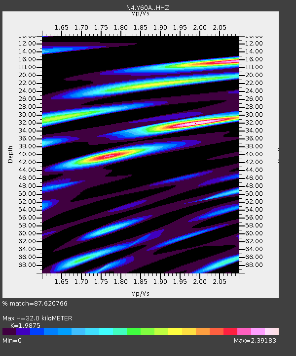
| Estimated Moho Depth: |
32.0 km |
| Estimated Crust Vp/Vs: |
1.99 |
| Assumed Crust Vp: |
6.565 km/s |
| Estimated Crust Vs: |
3.303 km/s |
| Estimated Crust Poisson's Ratio: |
0.33 |
|
| Radial Match: |
87.620766 % |
| Radial Bump: |
364 |
| Transverse Match: |
83.56987 % |
| Transverse Bump: |
339 |
| SOD ConfigId: |
13570011 |
| Insert Time: |
2019-04-30 18:53:36.120 +0000 |
| GWidth: |
2.5 |
| Max Bumps: |
400 |
| Tol: |
0.001 |
|

Signal To Noise
| Channel | StoN | STA | LTA |
| N4:Y60A: :HHZ:20180812T15:07:23.379994Z | 3.5389178 | 1.0003107E-6 | 2.8266004E-7 |
| N4:Y60A: :HHN:20180812T15:07:23.379994Z | 2.4694538 | 9.100953E-7 | 3.6854112E-7 |
| N4:Y60A: :HHE:20180812T15:07:23.379994Z | 1.2706697 | 4.9038874E-7 | 3.8592935E-7 |
| Arrivals |
| Ps | 5.1 SECOND |
| PpPs | 14 SECOND |
| PsPs/PpSs | 19 SECOND |


