You are here: Home > Network List > TA - USArray Transportable Network (new EarthScope stations) Stations List
> Station X20A Quemado, NM, USA > Earthquake Result Viewer
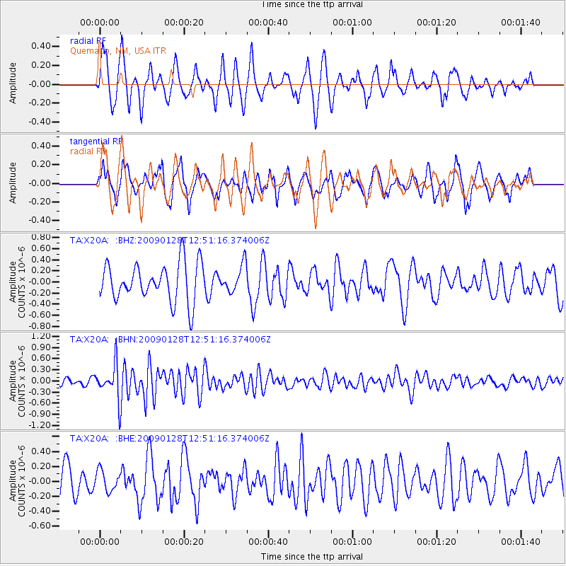
X20A Quemado, NM, USA - Earthquake Result Viewer
*The percent match for this event was below the threshold and hence no stack was calculated.
| Earthquake location: |
Samoa Islands Region |
| Earthquake latitude/longitude: |
-17.0/-172.1 |
| Earthquake time(UTC): |
2009/01/28 (028) 12:39:42 GMT |
| Earthquake Depth: |
10 km |
| Earthquake Magnitude: |
5.6 MB, 5.3 MS, 5.5 MW |
| Earthquake Catalog/Contributor: |
WHDF/NEIC |
|
| Network: |
TA USArray Transportable Network (new EarthScope stations) |
| Station: |
X20A Quemado, NM, USA |
| Lat/Lon: |
34.54 N/108.50 W |
| Elevation: |
2057 m |
|
| Distance: |
79.2 deg |
| Az: |
48.816 deg |
| Baz: |
240.75 deg |
| Ray Param: |
$rayparam |
*The percent match for this event was below the threshold and hence was not used in the summary stack. |
|
| Radial Match: |
60.407665 % |
| Radial Bump: |
380 |
| Transverse Match: |
51.815983 % |
| Transverse Bump: |
334 |
| SOD ConfigId: |
2658 |
| Insert Time: |
2010-03-06 13:45:37.348 +0000 |
| GWidth: |
2.5 |
| Max Bumps: |
400 |
| Tol: |
0.001 |
|
Signal To Noise
| Channel | StoN | STA | LTA |
| TA:X20A: :BHN:20090128T12:51:16.374006Z | 4.825834 | 4.771473E-7 | 9.887355E-8 |
| TA:X20A: :BHE:20090128T12:51:16.374006Z | 0.6177953 | 1.4196561E-7 | 2.2979394E-7 |
| TA:X20A: :BHZ:20090128T12:51:16.374006Z | 0.7300582 | 2.5139764E-7 | 3.4435286E-7 |
| Arrivals |
| Ps | |
| PpPs | |
| PsPs/PpSs | |


