You are here: Home > Network List > TA - USArray Transportable Network (new EarthScope stations) Stations List
> Station X20A Quemado, NM, USA > Earthquake Result Viewer
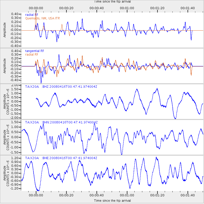
X20A Quemado, NM, USA - Earthquake Result Viewer
*The percent match for this event was below the threshold and hence no stack was calculated.
| Earthquake location: |
Tonga Islands |
| Earthquake latitude/longitude: |
-18.6/-175.7 |
| Earthquake time(UTC): |
2008/04/16 (107) 00:35:48 GMT |
| Earthquake Depth: |
10 km |
| Earthquake Magnitude: |
5.6 MB, 6.3 MS, 6.3 MW, 6.3 MW |
| Earthquake Catalog/Contributor: |
WHDF/NEIC |
|
| Network: |
TA USArray Transportable Network (new EarthScope stations) |
| Station: |
X20A Quemado, NM, USA |
| Lat/Lon: |
34.54 N/108.50 W |
| Elevation: |
2057 m |
|
| Distance: |
82.9 deg |
| Az: |
50.08 deg |
| Baz: |
241.776 deg |
| Ray Param: |
$rayparam |
*The percent match for this event was below the threshold and hence was not used in the summary stack. |
|
| Radial Match: |
56.120537 % |
| Radial Bump: |
400 |
| Transverse Match: |
63.15478 % |
| Transverse Bump: |
400 |
| SOD ConfigId: |
2504 |
| Insert Time: |
2010-03-06 13:45:44.304 +0000 |
| GWidth: |
2.5 |
| Max Bumps: |
400 |
| Tol: |
0.001 |
|
Signal To Noise
| Channel | StoN | STA | LTA |
| TA:X20A: :BHN:20080416T00:47:41.974004Z | 1.8923576 | 8.581868E-7 | 4.535014E-7 |
| TA:X20A: :BHE:20080416T00:47:41.974004Z | 2.1329534 | 9.971351E-7 | 4.674903E-7 |
| TA:X20A: :BHZ:20080416T00:47:41.974004Z | 0.5726928 | 2.49387E-7 | 4.3546385E-7 |
| Arrivals |
| Ps | |
| PpPs | |
| PsPs/PpSs | |


