You are here: Home > Network List > TA - USArray Transportable Network (new EarthScope stations) Stations List
> Station X20A Quemado, NM, USA > Earthquake Result Viewer
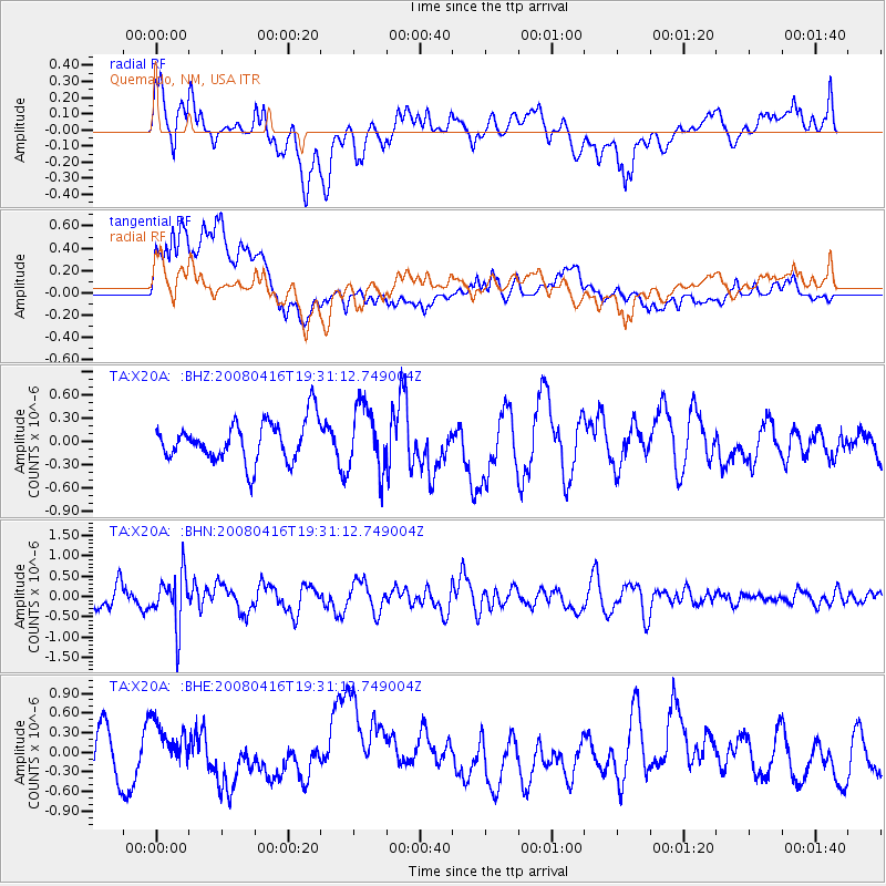
X20A Quemado, NM, USA - Earthquake Result Viewer
*The percent match for this event was below the threshold and hence no stack was calculated.
| Earthquake location: |
Eastern Honshu, Japan |
| Earthquake latitude/longitude: |
39.0/140.0 |
| Earthquake time(UTC): |
2008/04/16 (107) 19:19:36 GMT |
| Earthquake Depth: |
166 km |
| Earthquake Magnitude: |
5.6 MB, 5.8 MW, 5.8 MW |
| Earthquake Catalog/Contributor: |
WHDF/NEIC |
|
| Network: |
TA USArray Transportable Network (new EarthScope stations) |
| Station: |
X20A Quemado, NM, USA |
| Lat/Lon: |
34.54 N/108.50 W |
| Elevation: |
2057 m |
|
| Distance: |
83.2 deg |
| Az: |
50.669 deg |
| Baz: |
313.126 deg |
| Ray Param: |
$rayparam |
*The percent match for this event was below the threshold and hence was not used in the summary stack. |
|
| Radial Match: |
44.247032 % |
| Radial Bump: |
400 |
| Transverse Match: |
73.46322 % |
| Transverse Bump: |
400 |
| SOD ConfigId: |
2504 |
| Insert Time: |
2010-03-06 13:45:47.159 +0000 |
| GWidth: |
2.5 |
| Max Bumps: |
400 |
| Tol: |
0.001 |
|
Signal To Noise
| Channel | StoN | STA | LTA |
| TA:X20A: :BHN:20080416T19:31:12.749004Z | 2.8131936 | 6.3023276E-7 | 2.2402752E-7 |
| TA:X20A: :BHE:20080416T19:31:12.749004Z | 0.8818068 | 3.4224666E-7 | 3.8811982E-7 |
| TA:X20A: :BHZ:20080416T19:31:12.749004Z | 1.5994266 | 4.1645563E-7 | 2.603781E-7 |
| Arrivals |
| Ps | |
| PpPs | |
| PsPs/PpSs | |


