You are here: Home > Network List > TA - USArray Transportable Network (new EarthScope stations) Stations List
> Station X20A Quemado, NM, USA > Earthquake Result Viewer
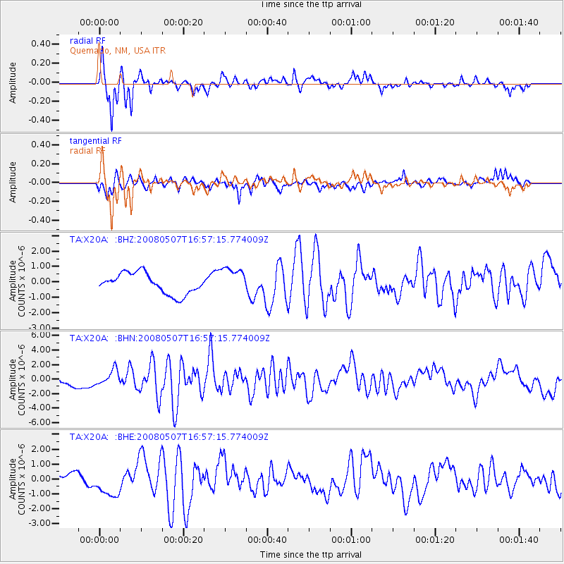
X20A Quemado, NM, USA - Earthquake Result Viewer
*The percent match for this event was below the threshold and hence no stack was calculated.
| Earthquake location: |
Near East Coast Of Honshu, Japan |
| Earthquake latitude/longitude: |
36.2/141.5 |
| Earthquake time(UTC): |
2008/05/07 (128) 16:45:20 GMT |
| Earthquake Depth: |
39 km |
| Earthquake Magnitude: |
6.1 MB, 6.7 MS, 6.8 MW, 6.8 MW |
| Earthquake Catalog/Contributor: |
WHDF/NEIC |
|
| Network: |
TA USArray Transportable Network (new EarthScope stations) |
| Station: |
X20A Quemado, NM, USA |
| Lat/Lon: |
34.54 N/108.50 W |
| Elevation: |
2057 m |
|
| Distance: |
84.1 deg |
| Az: |
51.257 deg |
| Baz: |
310.124 deg |
| Ray Param: |
$rayparam |
*The percent match for this event was below the threshold and hence was not used in the summary stack. |
|
| Radial Match: |
82.54455 % |
| Radial Bump: |
309 |
| Transverse Match: |
54.82789 % |
| Transverse Bump: |
393 |
| SOD ConfigId: |
2504 |
| Insert Time: |
2010-03-06 13:45:53.357 +0000 |
| GWidth: |
2.5 |
| Max Bumps: |
400 |
| Tol: |
0.001 |
|
Signal To Noise
| Channel | StoN | STA | LTA |
| TA:X20A: :BHN:20080507T16:57:15.774009Z | 2.116719 | 1.0276656E-6 | 4.854993E-7 |
| TA:X20A: :BHE:20080507T16:57:15.774009Z | 1.753569 | 9.690106E-7 | 5.5259335E-7 |
| TA:X20A: :BHZ:20080507T16:57:15.774009Z | 1.3201745 | 8.808609E-7 | 6.672307E-7 |
| Arrivals |
| Ps | |
| PpPs | |
| PsPs/PpSs | |


