You are here: Home > Network List > PE - Penn State Network Stations List
> Station PACW Cowans Gap State Park, Fort Loudon, PA > Earthquake Result Viewer
PACW Cowans Gap State Park, Fort Loudon, PA - Earthquake Result Viewer
| Earthquake location: |
Northern Alaska |
| Earthquake latitude/longitude: |
69.6/-145.3 |
| Earthquake time(UTC): |
2018/08/12 (224) 14:58:54 GMT |
| Earthquake Depth: |
2.2 km |
| Earthquake Magnitude: |
6.3 ml |
| Earthquake Catalog/Contributor: |
NEIC PDE/ak |
|
| Network: |
PE Penn State Network |
| Station: |
PACW Cowans Gap State Park, Fort Loudon, PA |
| Lat/Lon: |
40.00 N/77.92 W |
| Elevation: |
394 m |
|
| Distance: |
45.3 deg |
| Az: |
94.18 deg |
| Baz: |
332.869 deg |
| Ray Param: |
0.071379974 |
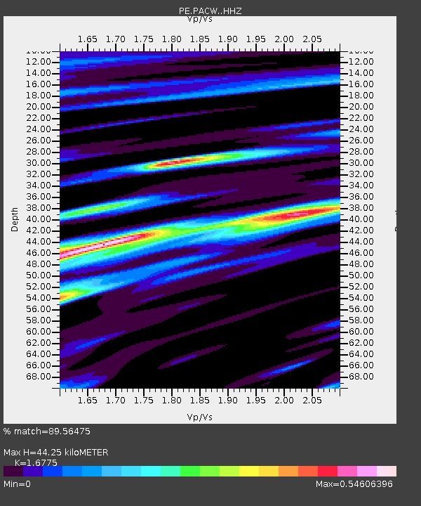
| Estimated Moho Depth: |
44.25 km |
| Estimated Crust Vp/Vs: |
1.68 |
| Assumed Crust Vp: |
6.419 km/s |
| Estimated Crust Vs: |
3.827 km/s |
| Estimated Crust Poisson's Ratio: |
0.22 |
|
| Radial Match: |
89.56475 % |
| Radial Bump: |
374 |
| Transverse Match: |
69.16246 % |
| Transverse Bump: |
400 |
| SOD ConfigId: |
13570011 |
| Insert Time: |
2019-04-30 18:54:54.190 +0000 |
| GWidth: |
2.5 |
| Max Bumps: |
400 |
| Tol: |
0.001 |
|

Signal To Noise
| Channel | StoN | STA | LTA |
| PE:PACW: :HHZ:20180812T15:06:42.569997Z | 50.801712 | 2.7125275E-6 | 5.3394412E-8 |
| PE:PACW: :HHN:20180812T15:06:42.569997Z | 7.2955117 | 1.1465991E-6 | 1.57165E-7 |
| PE:PACW: :HHE:20180812T15:06:42.569997Z | 3.9713743 | 4.6319929E-7 | 1.1663451E-7 |
| Arrivals |
| Ps | 5.0 SECOND |
| PpPs | 17 SECOND |
| PsPs/PpSs | 22 SECOND |


