You are here: Home > Network List > PL - Polish Seismological Network Stations List
> Station SUW PLSN/GEOFON Station Suwalki, Poland > Earthquake Result Viewer
SUW PLSN/GEOFON Station Suwalki, Poland - Earthquake Result Viewer
| Earthquake location: |
Northern Alaska |
| Earthquake latitude/longitude: |
69.6/-145.3 |
| Earthquake time(UTC): |
2018/08/12 (224) 14:58:54 GMT |
| Earthquake Depth: |
2.2 km |
| Earthquake Magnitude: |
6.3 ml |
| Earthquake Catalog/Contributor: |
NEIC PDE/ak |
|
| Network: |
PL Polish Seismological Network |
| Station: |
SUW PLSN/GEOFON Station Suwalki, Poland |
| Lat/Lon: |
54.01 N/23.18 E |
| Elevation: |
152 m |
|
| Distance: |
56.4 deg |
| Az: |
8.13 deg |
| Baz: |
355.172 deg |
| Ray Param: |
0.06415356 |
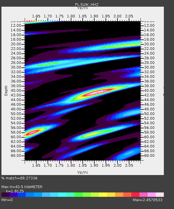
| Estimated Moho Depth: |
40.5 km |
| Estimated Crust Vp/Vs: |
1.91 |
| Assumed Crust Vp: |
6.53 km/s |
| Estimated Crust Vs: |
3.415 km/s |
| Estimated Crust Poisson's Ratio: |
0.31 |
|
| Radial Match: |
89.27336 % |
| Radial Bump: |
400 |
| Transverse Match: |
69.52749 % |
| Transverse Bump: |
400 |
| SOD ConfigId: |
13570011 |
| Insert Time: |
2019-04-30 18:55:15.390 +0000 |
| GWidth: |
2.5 |
| Max Bumps: |
400 |
| Tol: |
0.001 |
|

Signal To Noise
| Channel | StoN | STA | LTA |
| PL:SUW: :HHZ:20180812T15:08:06.283986Z | 3.8789957 | 6.04419E-7 | 1.5581843E-7 |
| PL:SUW: :HHN:20180812T15:08:06.283986Z | 1.168325 | 5.515787E-7 | 4.7211068E-7 |
| PL:SUW: :HHE:20180812T15:08:06.283986Z | 1.5646427 | 4.076893E-7 | 2.6056384E-7 |
| Arrivals |
| Ps | 5.9 SECOND |
| PpPs | 17 SECOND |
| PsPs/PpSs | 23 SECOND |


