You are here: Home > Network List > PM - Portuguese National Seismic Network Stations List
> Station PFVI PM.PFVI > Earthquake Result Viewer
PFVI PM.PFVI - Earthquake Result Viewer
| Earthquake location: |
Northern Alaska |
| Earthquake latitude/longitude: |
69.6/-145.3 |
| Earthquake time(UTC): |
2018/08/12 (224) 14:58:54 GMT |
| Earthquake Depth: |
2.2 km |
| Earthquake Magnitude: |
6.3 ml |
| Earthquake Catalog/Contributor: |
NEIC PDE/ak |
|
| Network: |
PM Portuguese National Seismic Network |
| Station: |
PFVI PM.PFVI |
| Lat/Lon: |
37.13 N/8.83 W |
| Elevation: |
189 m |
|
| Distance: |
68.9 deg |
| Az: |
36.14 deg |
| Baz: |
344.976 deg |
| Ray Param: |
0.055987295 |
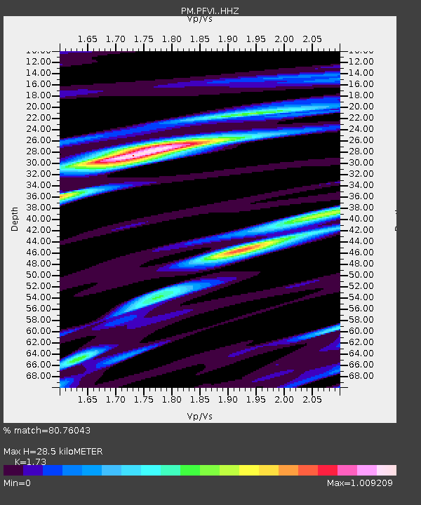
| Estimated Moho Depth: |
28.5 km |
| Estimated Crust Vp/Vs: |
1.73 |
| Assumed Crust Vp: |
6.048 km/s |
| Estimated Crust Vs: |
3.496 km/s |
| Estimated Crust Poisson's Ratio: |
0.25 |
|
| Radial Match: |
80.76043 % |
| Radial Bump: |
400 |
| Transverse Match: |
74.4351 % |
| Transverse Bump: |
400 |
| SOD ConfigId: |
13570011 |
| Insert Time: |
2019-04-30 18:55:16.342 +0000 |
| GWidth: |
2.5 |
| Max Bumps: |
400 |
| Tol: |
0.001 |
|

Signal To Noise
| Channel | StoN | STA | LTA |
| PM:PFVI: :HHZ:20180812T15:09:29.499989Z | 3.3240511 | 1.0761981E-6 | 3.2376101E-7 |
| PM:PFVI: :HHN:20180812T15:09:29.499989Z | 1.9308805 | 3.5406833E-7 | 1.8337143E-7 |
| PM:PFVI: :HHE:20180812T15:09:29.499989Z | 0.6640867 | 2.0642547E-7 | 3.1084116E-7 |
| Arrivals |
| Ps | 3.6 SECOND |
| PpPs | 12 SECOND |
| PsPs/PpSs | 16 SECOND |


