You are here: Home > Network List > TA - USArray Transportable Network (new EarthScope stations) Stations List
> Station X20A Quemado, NM, USA > Earthquake Result Viewer
X20A Quemado, NM, USA - Earthquake Result Viewer
*The percent match for this event was below the threshold and hence no stack was calculated.
| Earthquake location: |
North Of Ascension Island |
| Earthquake latitude/longitude: |
-0.2/-17.4 |
| Earthquake time(UTC): |
2008/08/28 (241) 15:22:23 GMT |
| Earthquake Depth: |
15 km |
| Earthquake Magnitude: |
5.8 MB, 5.9 MS, 6.3 MW, 6.3 MW |
| Earthquake Catalog/Contributor: |
WHDF/NEIC |
|
| Network: |
TA USArray Transportable Network (new EarthScope stations) |
| Station: |
X20A Quemado, NM, USA |
| Lat/Lon: |
34.54 N/108.50 W |
| Elevation: |
2057 m |
|
| Distance: |
91.1 deg |
| Az: |
304.364 deg |
| Baz: |
89.559 deg |
| Ray Param: |
$rayparam |
*The percent match for this event was below the threshold and hence was not used in the summary stack. |
|
| Radial Match: |
63.311337 % |
| Radial Bump: |
400 |
| Transverse Match: |
66.93856 % |
| Transverse Bump: |
400 |
| SOD ConfigId: |
2504 |
| Insert Time: |
2010-03-06 13:46:09.933 +0000 |
| GWidth: |
2.5 |
| Max Bumps: |
400 |
| Tol: |
0.001 |
|
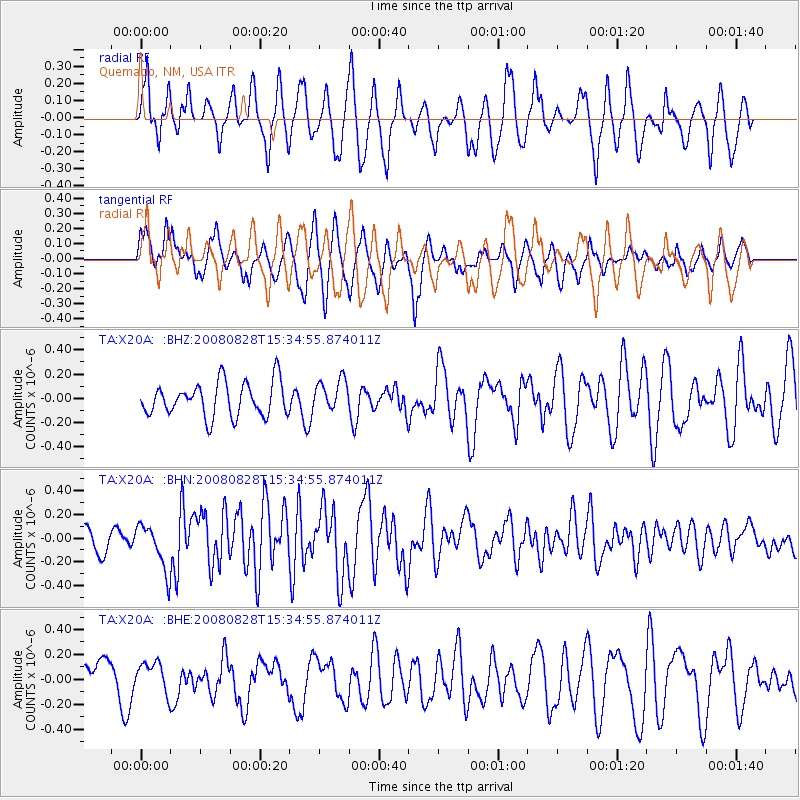
Signal To Noise
| Channel | StoN | STA | LTA |
| TA:X20A: :BHN:20080828T15:34:55.874011Z | 1.8160671 | 1.9446473E-7 | 1.0708015E-7 |
| TA:X20A: :BHE:20080828T15:34:55.874011Z | 0.88063985 | 1.2092302E-7 | 1.373127E-7 |
| TA:X20A: :BHZ:20080828T15:34:55.874011Z | 0.91619784 | 1.282942E-7 | 1.4002893E-7 |
| Arrivals |
| Ps | |
| PpPs | |
| PsPs/PpSs | |


