You are here: Home > Network List > TA - USArray Transportable Network (new EarthScope stations) Stations List
> Station X20A Quemado, NM, USA > Earthquake Result Viewer
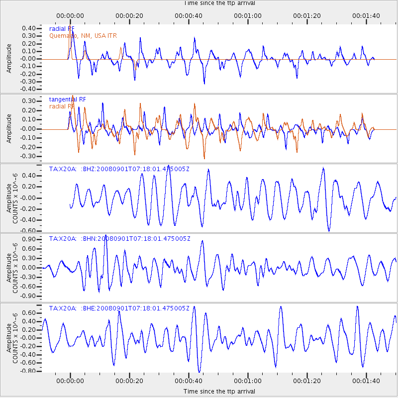
X20A Quemado, NM, USA - Earthquake Result Viewer
*The percent match for this event was below the threshold and hence no stack was calculated.
| Earthquake location: |
Fiji Islands Region |
| Earthquake latitude/longitude: |
-15.3/-176.4 |
| Earthquake time(UTC): |
2008/09/01 (245) 07:06:16 GMT |
| Earthquake Depth: |
10 km |
| Earthquake Magnitude: |
5.6 MS, 5.4 MB, 5.7 MW, 5.7 MW |
| Earthquake Catalog/Contributor: |
WHDF/NEIC |
|
| Network: |
TA USArray Transportable Network (new EarthScope stations) |
| Station: |
X20A Quemado, NM, USA |
| Lat/Lon: |
34.54 N/108.50 W |
| Elevation: |
2057 m |
|
| Distance: |
81.3 deg |
| Az: |
50.705 deg |
| Baz: |
244.805 deg |
| Ray Param: |
$rayparam |
*The percent match for this event was below the threshold and hence was not used in the summary stack. |
|
| Radial Match: |
74.32237 % |
| Radial Bump: |
336 |
| Transverse Match: |
49.061394 % |
| Transverse Bump: |
292 |
| SOD ConfigId: |
2504 |
| Insert Time: |
2010-03-06 13:46:12.290 +0000 |
| GWidth: |
2.5 |
| Max Bumps: |
400 |
| Tol: |
0.001 |
|
Signal To Noise
| Channel | StoN | STA | LTA |
| TA:X20A: :BHN:20080901T07:18:01.475005Z | 2.235568 | 2.4717653E-7 | 1.1056543E-7 |
| TA:X20A: :BHE:20080901T07:18:01.475005Z | 0.7039477 | 1.2643122E-7 | 1.7960312E-7 |
| TA:X20A: :BHZ:20080901T07:18:01.475005Z | 2.0804248 | 3.617624E-7 | 1.7388872E-7 |
| Arrivals |
| Ps | |
| PpPs | |
| PsPs/PpSs | |


