You are here: Home > Network List > CI - Caltech Regional Seismic Network Stations List
> Station PHL Parkhill, California, USA > Earthquake Result Viewer
PHL Parkhill, California, USA - Earthquake Result Viewer
| Earthquake location: |
Near Coast Of Chiapas, Mexico |
| Earthquake latitude/longitude: |
16.0/-93.8 |
| Earthquake time(UTC): |
1998/06/07 (158) 23:20:13 GMT |
| Earthquake Depth: |
87 km |
| Earthquake Magnitude: |
5.8 MB, 6.3 UNKNOWN, 6.3 MW |
| Earthquake Catalog/Contributor: |
WHDF/NEIC |
|
| Network: |
CI Caltech Regional Seismic Network |
| Station: |
PHL Parkhill, California, USA |
| Lat/Lon: |
35.41 N/120.55 W |
| Elevation: |
351 m |
|
| Distance: |
30.8 deg |
| Az: |
314.022 deg |
| Baz: |
122.138 deg |
| Ray Param: |
0.07910588 |
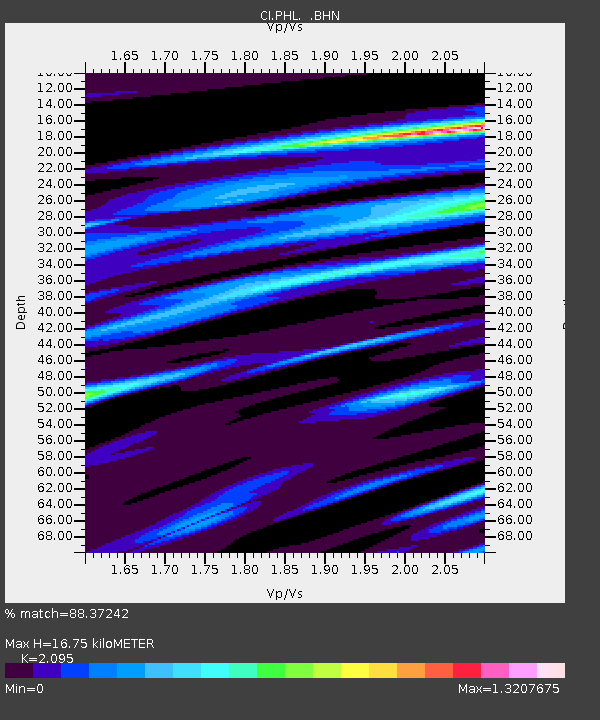
| Estimated Moho Depth: |
16.75 km |
| Estimated Crust Vp/Vs: |
2.10 |
| Assumed Crust Vp: |
6.183 km/s |
| Estimated Crust Vs: |
2.951 km/s |
| Estimated Crust Poisson's Ratio: |
0.35 |
|
| Radial Match: |
88.37242 % |
| Radial Bump: |
393 |
| Transverse Match: |
65.37167 % |
| Transverse Bump: |
400 |
| SOD ConfigId: |
3787 |
| Insert Time: |
2010-02-26 02:11:11.786 +0000 |
| GWidth: |
2.5 |
| Max Bumps: |
400 |
| Tol: |
0.001 |
|
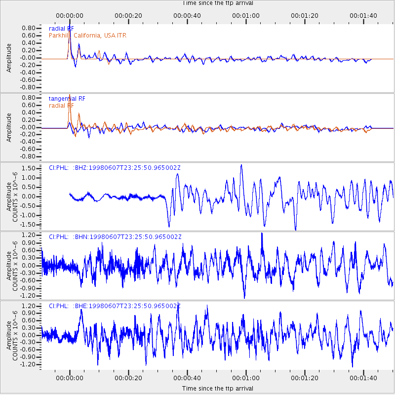
Signal To Noise
| Channel | StoN | STA | LTA |
| CI:PHL: :BHN:19980607T23:25:50.965002Z | 1.5451318 | 2.6420423E-7 | 1.709914E-7 |
| CI:PHL: :BHE:19980607T23:25:50.965002Z | 2.555667 | 4.3937882E-7 | 1.7192335E-7 |
| CI:PHL: :BHZ:19980607T23:25:50.965002Z | 5.3737535 | 5.694534E-7 | 1.059694E-7 |
| Arrivals |
| Ps | 3.2 SECOND |
| PpPs | 7.9 SECOND |
| PsPs/PpSs | 11 SECOND |


