You are here: Home > Network List > TA - USArray Transportable Network (new EarthScope stations) Stations List
> Station L61B Northampton, MA, USA > Earthquake Result Viewer
L61B Northampton, MA, USA - Earthquake Result Viewer
| Earthquake location: |
Northern Alaska |
| Earthquake latitude/longitude: |
69.6/-145.3 |
| Earthquake time(UTC): |
2018/08/12 (224) 14:58:54 GMT |
| Earthquake Depth: |
2.2 km |
| Earthquake Magnitude: |
6.3 ml |
| Earthquake Catalog/Contributor: |
NEIC PDE/ak |
|
| Network: |
TA USArray Transportable Network (new EarthScope stations) |
| Station: |
L61B Northampton, MA, USA |
| Lat/Lon: |
42.45 N/72.68 W |
| Elevation: |
261 m |
|
| Distance: |
45.0 deg |
| Az: |
87.631 deg |
| Baz: |
331.693 deg |
| Ray Param: |
0.07159767 |
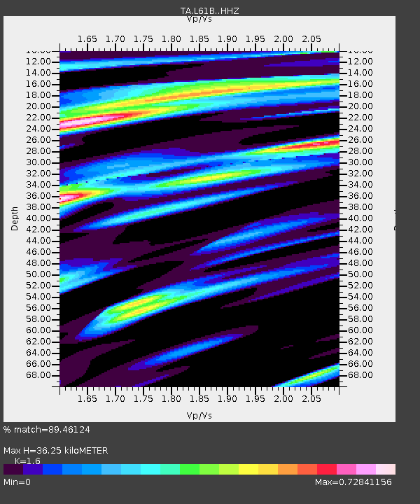
| Estimated Moho Depth: |
36.25 km |
| Estimated Crust Vp/Vs: |
1.60 |
| Assumed Crust Vp: |
6.419 km/s |
| Estimated Crust Vs: |
4.012 km/s |
| Estimated Crust Poisson's Ratio: |
0.18 |
|
| Radial Match: |
89.46124 % |
| Radial Bump: |
248 |
| Transverse Match: |
79.623985 % |
| Transverse Bump: |
378 |
| SOD ConfigId: |
13570011 |
| Insert Time: |
2019-04-30 18:56:02.334 +0000 |
| GWidth: |
2.5 |
| Max Bumps: |
400 |
| Tol: |
0.001 |
|

Signal To Noise
| Channel | StoN | STA | LTA |
| TA:L61B: :HHZ:20180812T15:06:39.960011Z | 9.204331 | 1.2445777E-6 | 1.3521651E-7 |
| TA:L61B: :HHN:20180812T15:06:39.960011Z | 6.2064133 | 6.660791E-7 | 1.073211E-7 |
| TA:L61B: :HHE:20180812T15:06:39.960011Z | 3.8880515 | 2.825999E-7 | 7.2684195E-8 |
| Arrivals |
| Ps | 3.6 SECOND |
| PpPs | 14 SECOND |
| PsPs/PpSs | 17 SECOND |


