You are here: Home > Network List > TA - USArray Transportable Network (new EarthScope stations) Stations List
> Station X20A Quemado, NM, USA > Earthquake Result Viewer
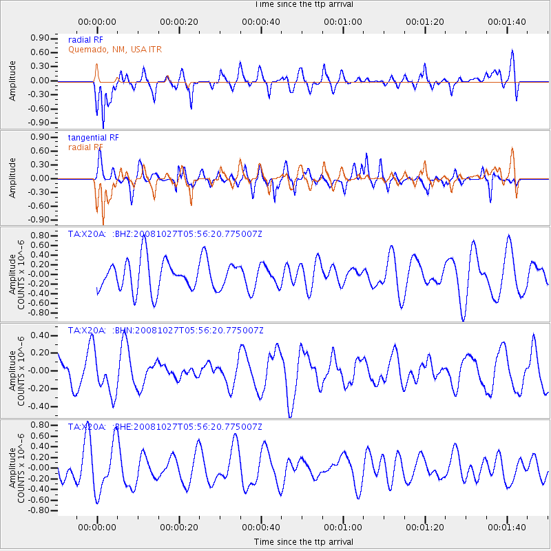
X20A Quemado, NM, USA - Earthquake Result Viewer
*The percent match for this event was below the threshold and hence no stack was calculated.
| Earthquake location: |
Vanuatu Islands |
| Earthquake latitude/longitude: |
-14.6/167.2 |
| Earthquake time(UTC): |
2008/10/27 (301) 05:43:50 GMT |
| Earthquake Depth: |
129 km |
| Earthquake Magnitude: |
5.6 MW, 5.2 MB, 5.6 MW |
| Earthquake Catalog/Contributor: |
WHDF/NEIC |
|
| Network: |
TA USArray Transportable Network (new EarthScope stations) |
| Station: |
X20A Quemado, NM, USA |
| Lat/Lon: |
34.54 N/108.50 W |
| Elevation: |
2057 m |
|
| Distance: |
93.6 deg |
| Az: |
55.391 deg |
| Baz: |
254.82 deg |
| Ray Param: |
$rayparam |
*The percent match for this event was below the threshold and hence was not used in the summary stack. |
|
| Radial Match: |
67.93671 % |
| Radial Bump: |
400 |
| Transverse Match: |
48.498013 % |
| Transverse Bump: |
400 |
| SOD ConfigId: |
2560 |
| Insert Time: |
2010-03-06 13:46:27.627 +0000 |
| GWidth: |
2.5 |
| Max Bumps: |
400 |
| Tol: |
0.001 |
|
Signal To Noise
| Channel | StoN | STA | LTA |
| TA:X20A: :BHN:20081027T05:56:20.775007Z | 1.7633708 | 2.249441E-7 | 1.2756485E-7 |
| TA:X20A: :BHE:20081027T05:56:20.775007Z | 1.5945909 | 4.572702E-7 | 2.867633E-7 |
| TA:X20A: :BHZ:20081027T05:56:20.775007Z | 0.7149996 | 2.2978843E-7 | 3.2138257E-7 |
| Arrivals |
| Ps | |
| PpPs | |
| PsPs/PpSs | |


