You are here: Home > Network List > TA - USArray Transportable Network (new EarthScope stations) Stations List
> Station X20A Quemado, NM, USA > Earthquake Result Viewer
X20A Quemado, NM, USA - Earthquake Result Viewer
*The percent match for this event was below the threshold and hence no stack was calculated.
| Earthquake location: |
Near East Coast Of Honshu, Japan |
| Earthquake latitude/longitude: |
40.2/142.2 |
| Earthquake time(UTC): |
2009/02/15 (046) 09:24:31 GMT |
| Earthquake Depth: |
33 km |
| Earthquake Magnitude: |
6.1 MB, 5.5 MS, 5.7 MW, 5.7 MW |
| Earthquake Catalog/Contributor: |
WHDF/NEIC |
|
| Network: |
TA USArray Transportable Network (new EarthScope stations) |
| Station: |
X20A Quemado, NM, USA |
| Lat/Lon: |
34.54 N/108.50 W |
| Elevation: |
2057 m |
|
| Distance: |
81.1 deg |
| Az: |
52.068 deg |
| Baz: |
312.994 deg |
| Ray Param: |
$rayparam |
*The percent match for this event was below the threshold and hence was not used in the summary stack. |
|
| Radial Match: |
50.47417 % |
| Radial Bump: |
400 |
| Transverse Match: |
61.60191 % |
| Transverse Bump: |
400 |
| SOD ConfigId: |
2658 |
| Insert Time: |
2010-03-06 13:46:31.213 +0000 |
| GWidth: |
2.5 |
| Max Bumps: |
400 |
| Tol: |
0.001 |
|
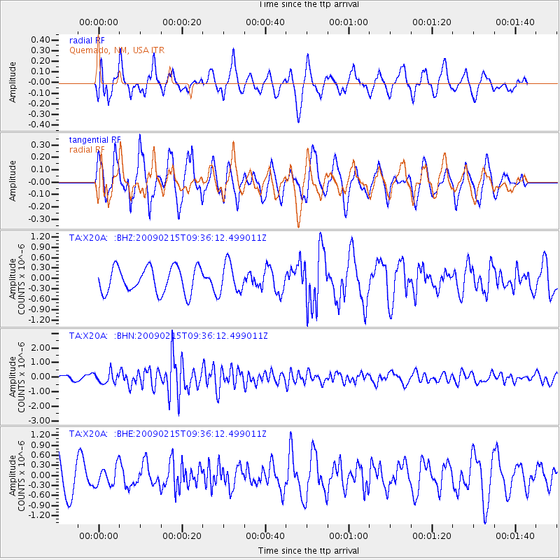
Signal To Noise
| Channel | StoN | STA | LTA |
| TA:X20A: :BHN:20090215T09:36:12.499011Z | 2.655973 | 3.7299327E-7 | 1.4043563E-7 |
| TA:X20A: :BHE:20090215T09:36:12.499011Z | 0.75789964 | 2.8927272E-7 | 3.8167684E-7 |
| TA:X20A: :BHZ:20090215T09:36:12.499011Z | 1.1484023 | 4.2325217E-7 | 3.6855738E-7 |
| Arrivals |
| Ps | |
| PpPs | |
| PsPs/PpSs | |


