You are here: Home > Network List > YN10 - San Jacinto Fault Zone Stations List
> Station RHIL RHIL > Earthquake Result Viewer
RHIL RHIL - Earthquake Result Viewer
| Earthquake location: |
Northern Alaska |
| Earthquake latitude/longitude: |
69.6/-145.3 |
| Earthquake time(UTC): |
2018/08/12 (224) 14:58:54 GMT |
| Earthquake Depth: |
2.2 km |
| Earthquake Magnitude: |
6.3 ml |
| Earthquake Catalog/Contributor: |
NEIC PDE/ak |
|
| Network: |
YN San Jacinto Fault Zone |
| Station: |
RHIL RHIL |
| Lat/Lon: |
33.67 N/116.77 W |
| Elevation: |
1557 m |
|
| Distance: |
39.3 deg |
| Az: |
141.017 deg |
| Baz: |
344.634 deg |
| Ray Param: |
0.075095475 |
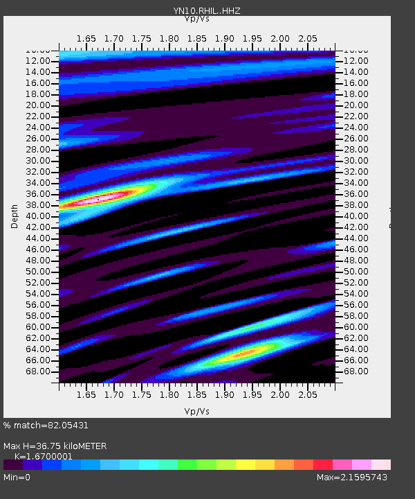
| Estimated Moho Depth: |
36.75 km |
| Estimated Crust Vp/Vs: |
1.67 |
| Assumed Crust Vp: |
6.264 km/s |
| Estimated Crust Vs: |
3.751 km/s |
| Estimated Crust Poisson's Ratio: |
0.22 |
|
| Radial Match: |
82.05431 % |
| Radial Bump: |
400 |
| Transverse Match: |
75.59691 % |
| Transverse Bump: |
400 |
| SOD ConfigId: |
13570011 |
| Insert Time: |
2019-04-30 18:57:30.389 +0000 |
| GWidth: |
2.5 |
| Max Bumps: |
400 |
| Tol: |
0.001 |
|

Signal To Noise
| Channel | StoN | STA | LTA |
| YN:RHIL: :HHZ:20180812T15:05:53.459004Z | 1.816491 | 2.708191E-7 | 1.4908915E-7 |
| YN:RHIL: :HHN:20180812T15:05:53.459004Z | 1.4659431 | 2.392321E-7 | 1.6319329E-7 |
| YN:RHIL: :HHE:20180812T15:05:53.459004Z | 1.2649524 | 1.9150113E-7 | 1.5138998E-7 |
| Arrivals |
| Ps | 4.2 SECOND |
| PpPs | 15 SECOND |
| PsPs/PpSs | 19 SECOND |


