You are here: Home > Network List > TA - USArray Transportable Network (new EarthScope stations) Stations List
> Station X20A Quemado, NM, USA > Earthquake Result Viewer
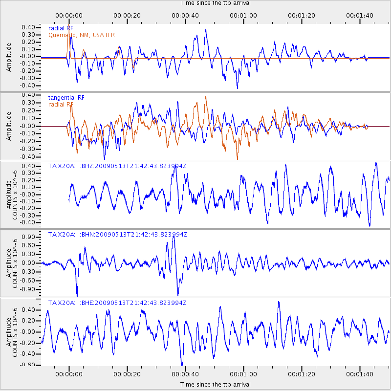
X20A Quemado, NM, USA - Earthquake Result Viewer
*The percent match for this event was below the threshold and hence no stack was calculated.
| Earthquake location: |
Tonga Islands |
| Earthquake latitude/longitude: |
-15.8/-173.5 |
| Earthquake time(UTC): |
2009/05/13 (133) 21:31:17 GMT |
| Earthquake Depth: |
85 km |
| Earthquake Magnitude: |
5.8 MW, 5.3 MB, 5.8 MW |
| Earthquake Catalog/Contributor: |
WHDF/NEIC |
|
| Network: |
TA USArray Transportable Network (new EarthScope stations) |
| Station: |
X20A Quemado, NM, USA |
| Lat/Lon: |
34.54 N/108.50 W |
| Elevation: |
2057 m |
|
| Distance: |
79.4 deg |
| Az: |
49.557 deg |
| Baz: |
242.595 deg |
| Ray Param: |
$rayparam |
*The percent match for this event was below the threshold and hence was not used in the summary stack. |
|
| Radial Match: |
73.251366 % |
| Radial Bump: |
400 |
| Transverse Match: |
66.54797 % |
| Transverse Bump: |
400 |
| SOD ConfigId: |
2760 |
| Insert Time: |
2010-03-06 13:46:32.642 +0000 |
| GWidth: |
2.5 |
| Max Bumps: |
400 |
| Tol: |
0.001 |
|
Signal To Noise
| Channel | StoN | STA | LTA |
| TA:X20A: :BHN:20090513T21:42:43.823994Z | 5.4579897 | 3.396125E-7 | 6.2223E-8 |
| TA:X20A: :BHE:20090513T21:42:43.823994Z | 1.5036861 | 2.2408443E-7 | 1.490234E-7 |
| TA:X20A: :BHZ:20090513T21:42:43.823994Z | 0.7670511 | 8.7344716E-8 | 1.1387079E-7 |
| Arrivals |
| Ps | |
| PpPs | |
| PsPs/PpSs | |


