You are here: Home > Network List > GS - US Geological Survey Networks Stations List
> Station DEC08 Decatur Surface Seismic Site, Decatur, IL, USA > Earthquake Result Viewer
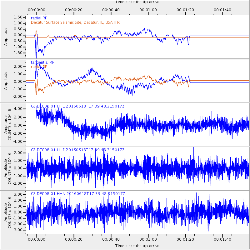
DEC08 Decatur Surface Seismic Site, Decatur, IL, USA - Earthquake Result Viewer
*The percent match for this event was below the threshold and hence no stack was calculated.
| Earthquake location: |
Chile-Argentina Border Region |
| Earthquake latitude/longitude: |
-24.2/-67.1 |
| Earthquake time(UTC): |
2016/06/18 (170) 17:29:44 GMT |
| Earthquake Depth: |
167 km |
| Earthquake Magnitude: |
5.5 MB |
| Earthquake Catalog/Contributor: |
NEIC PDE/NEIC COMCAT |
|
| Network: |
GS US Geological Survey Networks |
| Station: |
DEC08 Decatur Surface Seismic Site, Decatur, IL, USA |
| Lat/Lon: |
39.86 N/88.92 W |
| Elevation: |
210 m |
|
| Distance: |
66.9 deg |
| Az: |
341.867 deg |
| Baz: |
158.335 deg |
| Ray Param: |
$rayparam |
*The percent match for this event was below the threshold and hence was not used in the summary stack. |
|
| Radial Match: |
51.619457 % |
| Radial Bump: |
366 |
| Transverse Match: |
67.680885 % |
| Transverse Bump: |
400 |
| SOD ConfigId: |
1634031 |
| Insert Time: |
2016-07-02 17:32:06.410 +0000 |
| GWidth: |
2.5 |
| Max Bumps: |
400 |
| Tol: |
0.001 |
|
Signal To Noise
| Channel | StoN | STA | LTA |
| GS:DEC08:01:HHZ:20160618T17:39:48.315017Z | 1.2059989 | 7.9696156E-7 | 6.608311E-7 |
| GS:DEC08:01:HHN:20160618T17:39:48.315017Z | 1.1694806 | 1.0488728E-6 | 8.9687063E-7 |
| GS:DEC08:01:HHE:20160618T17:39:48.315017Z | 1.566213 | 2.6904443E-6 | 1.7178023E-6 |
| Arrivals |
| Ps | |
| PpPs | |
| PsPs/PpSs | |


