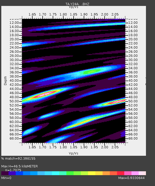
Y24A Capitan, NM, USA - Earthquake Result Viewer
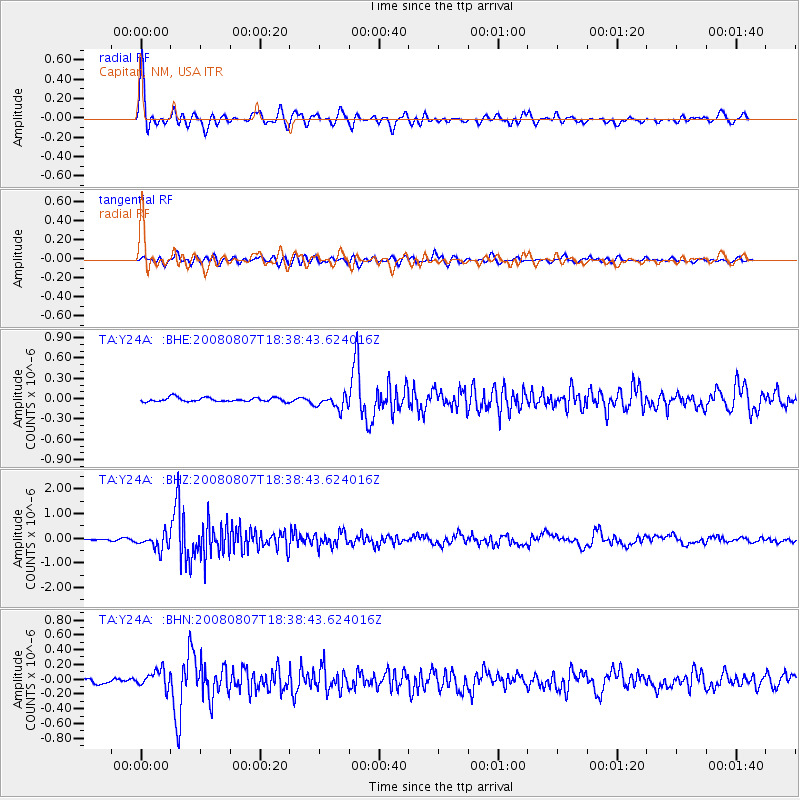
Earthquake location: Andreanof Islands, Aleutian Is.
Earthquake latitude/longitude: 52.2/-175.7
Earthquake time(UTC): 2008/08/07 (220) 18:30:03 GMT
Earthquake Depth: 12 km
Earthquake Magnitude: 5.6 MB, 5.5 MS, 5.8 MW, 5.8 MW
Earthquake Catalog/Contributor: WHDF/NEIC
Network: TA USArray Transportable Network (new EarthScope stations)
Station: Y24A Capitan, NM, USA
Lat/Lon: 33.93 N/105.44 W
Elevation: 1827 m
Distance: 52.3 deg
Az: 81.266 deg
Baz: 312.964 deg
Ray Param: 0.06682111
Estimated Moho Depth: 46.5 km
Estimated Crust Vp/Vs: 1.71
Assumed Crust Vp: 6.232 km/s
Estimated Crust Vs: 3.65 km/s
Estimated Crust Poisson's Ratio: 0.24
Radial Match: 92.398155 %
Radial Bump: 400
Transverse Match: 77.37935 %
Transverse Bump: 400
SOD ConfigId: 2504
Insert Time: 2010-03-06 13:46:53.320 +0000
GWidth: 2.5
Max Bumps: 400
Tol: 0.001

Signal To Noise

ChannelStoNSTALTA
TA:Y24A: :BHZ:20080807T18:38:43.624016Z6.21777253.0980192E-74.9825225E-8
TA:Y24A: :BHN:20080807T18:38:43.624016Z2.97400241.1871699E-73.9918255E-8
TA:Y24A: :BHE:20080807T18:38:43.624016Z3.48074771.02581225E-72.947103E-8
Arrivals
Ps5.6 SECOND
PpPs19 SECOND
PsPs/PpSs25 SECOND