You are here: Home > Network List > CI - Caltech Regional Seismic Network Stations List
> Station SWS Sam W. Stewart, Westmorland, CA, USA > Earthquake Result Viewer
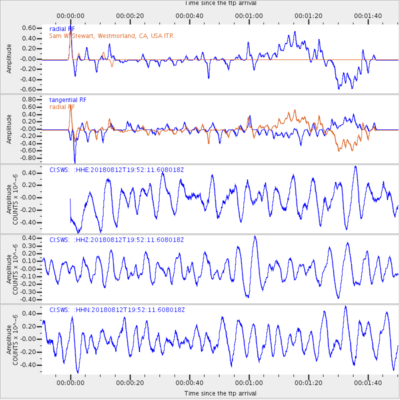
SWS Sam W. Stewart, Westmorland, CA, USA - Earthquake Result Viewer
*The percent match for this event was below the threshold and hence no stack was calculated.
| Earthquake location: |
Southeast Of Easter Island |
| Earthquake latitude/longitude: |
-35.7/-102.4 |
| Earthquake time(UTC): |
2018/08/12 (224) 19:41:34 GMT |
| Earthquake Depth: |
10 km |
| Earthquake Magnitude: |
5.6 Mww |
| Earthquake Catalog/Contributor: |
NEIC PDE/us |
|
| Network: |
CI Caltech Regional Seismic Network |
| Station: |
SWS Sam W. Stewart, Westmorland, CA, USA |
| Lat/Lon: |
32.94 N/115.80 W |
| Elevation: |
140 m |
|
| Distance: |
69.4 deg |
| Az: |
347.962 deg |
| Baz: |
168.352 deg |
| Ray Param: |
$rayparam |
*The percent match for this event was below the threshold and hence was not used in the summary stack. |
|
| Radial Match: |
49.471523 % |
| Radial Bump: |
400 |
| Transverse Match: |
56.769966 % |
| Transverse Bump: |
400 |
| SOD ConfigId: |
13570011 |
| Insert Time: |
2019-04-30 19:06:59.645 +0000 |
| GWidth: |
2.5 |
| Max Bumps: |
400 |
| Tol: |
0.001 |
|
Signal To Noise
| Channel | StoN | STA | LTA |
| CI:SWS: :HHZ:20180812T19:52:11.608018Z | 0.8730008 | 8.673297E-8 | 9.935039E-8 |
| CI:SWS: :HHN:20180812T19:52:11.608018Z | 1.4567299 | 3.1883718E-7 | 2.1887186E-7 |
| CI:SWS: :HHE:20180812T19:52:11.608018Z | 1.225287 | 2.974542E-7 | 2.4276287E-7 |
| Arrivals |
| Ps | |
| PpPs | |
| PsPs/PpSs | |


