You are here: Home > Network List > CI - Caltech Regional Seismic Network Stations List
> Station TIN Tinemaha, Big Pine, CA, USA > Earthquake Result Viewer
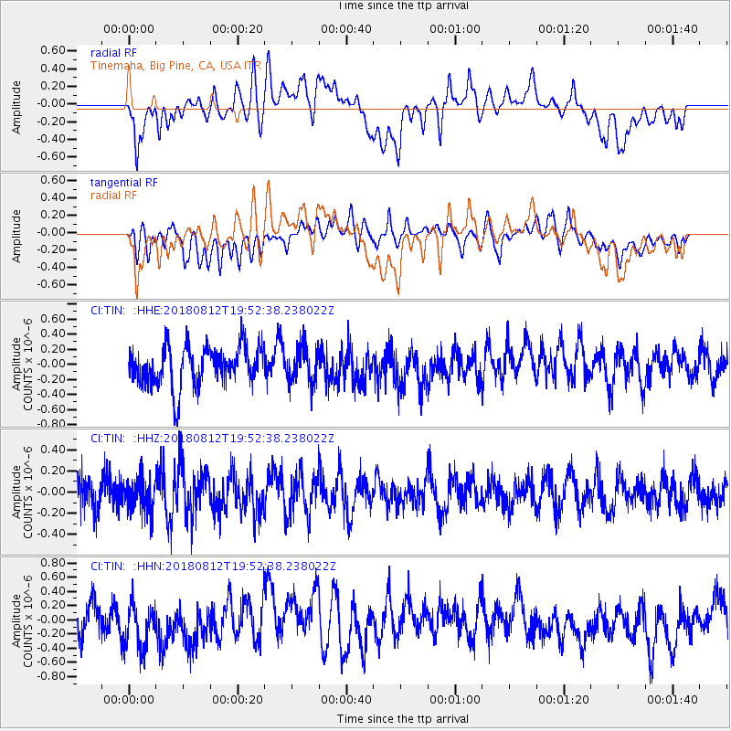
TIN Tinemaha, Big Pine, CA, USA - Earthquake Result Viewer
*The percent match for this event was below the threshold and hence no stack was calculated.
| Earthquake location: |
Southeast Of Easter Island |
| Earthquake latitude/longitude: |
-35.7/-102.4 |
| Earthquake time(UTC): |
2018/08/12 (224) 19:41:34 GMT |
| Earthquake Depth: |
10 km |
| Earthquake Magnitude: |
5.6 Mww |
| Earthquake Catalog/Contributor: |
NEIC PDE/us |
|
| Network: |
CI Caltech Regional Seismic Network |
| Station: |
TIN Tinemaha, Big Pine, CA, USA |
| Lat/Lon: |
37.05 N/118.23 W |
| Elevation: |
1197 m |
|
| Distance: |
73.9 deg |
| Az: |
346.844 deg |
| Baz: |
166.608 deg |
| Ray Param: |
$rayparam |
*The percent match for this event was below the threshold and hence was not used in the summary stack. |
|
| Radial Match: |
48.627155 % |
| Radial Bump: |
400 |
| Transverse Match: |
39.186333 % |
| Transverse Bump: |
400 |
| SOD ConfigId: |
13570011 |
| Insert Time: |
2019-04-30 19:07:01.308 +0000 |
| GWidth: |
2.5 |
| Max Bumps: |
400 |
| Tol: |
0.001 |
|
Signal To Noise
| Channel | StoN | STA | LTA |
| CI:TIN: :HHZ:20180812T19:52:38.238022Z | 1.0164633 | 1.5705166E-7 | 1.5450794E-7 |
| CI:TIN: :HHN:20180812T19:52:38.238022Z | 1.2573298 | 3.1808196E-7 | 2.5298212E-7 |
| CI:TIN: :HHE:20180812T19:52:38.238022Z | 0.9299815 | 2.3748107E-7 | 2.5536104E-7 |
| Arrivals |
| Ps | |
| PpPs | |
| PsPs/PpSs | |


