You are here: Home > Network List > TA - USArray Transportable Network (new EarthScope stations) Stations List
> Station Y24A Capitan, NM, USA > Earthquake Result Viewer
Y24A Capitan, NM, USA - Earthquake Result Viewer

| Earthquake location: |
Virgin Islands |
| Earthquake latitude/longitude: |
19.2/-64.8 |
| Earthquake time(UTC): |
2008/10/11 (285) 10:40:14 GMT |
| Earthquake Depth: |
23 km |
| Earthquake Magnitude: |
6.1 MB, 5.9 MS, 6.1 MW, 6.0 MW |
| Earthquake Catalog/Contributor: |
WHDF/NEIC |
|
| Network: |
TA USArray Transportable Network (new EarthScope stations) |
| Station: |
Y24A Capitan, NM, USA |
| Lat/Lon: |
33.93 N/105.44 W |
| Elevation: |
1827 m |
|
| Distance: |
38.9 deg |
| Az: |
300.532 deg |
| Baz: |
101.702 deg |
| Ray Param: |
0.07524827 |
| Estimated Moho Depth: |
27.5 km |
| Estimated Crust Vp/Vs: |
1.62 |
| Assumed Crust Vp: |
6.232 km/s |
| Estimated Crust Vs: |
3.853 km/s |
| Estimated Crust Poisson's Ratio: |
0.19 |
|
| Radial Match: |
80.45329 % |
| Radial Bump: |
400 |
| Transverse Match: |
64.159164 % |
| Transverse Bump: |
400 |
| SOD ConfigId: |
2556 |
| Insert Time: |
2010-03-06 13:47:00.864 +0000 |
| GWidth: |
2.5 |
| Max Bumps: |
400 |
| Tol: |
0.001 |
|
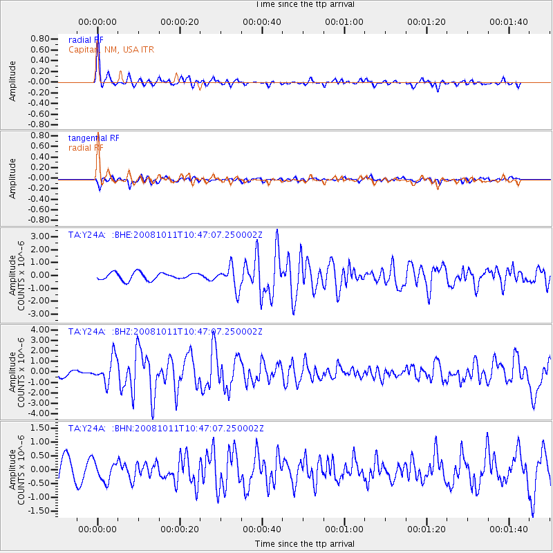
Signal To Noise
| Channel | StoN | STA | LTA |
| TA:Y24A: :BHZ:20081011T10:47:07.250002Z | 3.5011303 | 1.2512363E-6 | 3.5738069E-7 |
| TA:Y24A: :BHN:20081011T10:47:07.250002Z | 0.6161604 | 3.3539658E-7 | 5.4433326E-7 |
| TA:Y24A: :BHE:20081011T10:47:07.250002Z | 3.2690046 | 9.1545803E-7 | 2.8004183E-7 |
| Arrivals |
| Ps | 2.9 SECOND |
| PpPs | 11 SECOND |
| PsPs/PpSs | 14 SECOND |


