You are here: Home > Network List > TA - USArray Transportable Network (new EarthScope stations) Stations List
> Station Y24A Capitan, NM, USA > Earthquake Result Viewer
Y24A Capitan, NM, USA - Earthquake Result Viewer
| Earthquake location: |
Tonga Islands |
| Earthquake latitude/longitude: |
-21.9/-173.8 |
| Earthquake time(UTC): |
2008/10/19 (293) 05:10:33 GMT |
| Earthquake Depth: |
29 km |
| Earthquake Magnitude: |
6.8 MB, 7.0 MS, 6.9 MW, 6.9 MW |
| Earthquake Catalog/Contributor: |
WHDF/NEIC |
|
| Network: |
TA USArray Transportable Network (new EarthScope stations) |
| Station: |
Y24A Capitan, NM, USA |
| Lat/Lon: |
33.93 N/105.44 W |
| Elevation: |
1827 m |
|
| Distance: |
85.5 deg |
| Az: |
50.844 deg |
| Baz: |
240.032 deg |
| Ray Param: |
0.044701762 |
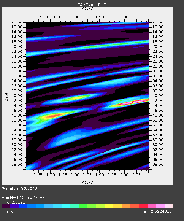
| Estimated Moho Depth: |
42.5 km |
| Estimated Crust Vp/Vs: |
2.03 |
| Assumed Crust Vp: |
6.232 km/s |
| Estimated Crust Vs: |
3.066 km/s |
| Estimated Crust Poisson's Ratio: |
0.34 |
|
| Radial Match: |
96.6048 % |
| Radial Bump: |
400 |
| Transverse Match: |
93.34409 % |
| Transverse Bump: |
400 |
| SOD ConfigId: |
2556 |
| Insert Time: |
2010-03-06 13:47:03.436 +0000 |
| GWidth: |
2.5 |
| Max Bumps: |
400 |
| Tol: |
0.001 |
|

Signal To Noise
| Channel | StoN | STA | LTA |
| TA:Y24A: :BHZ:20081019T05:22:37.600002Z | 72.96656 | 8.046853E-6 | 1.1028138E-7 |
| TA:Y24A: :BHN:20081019T05:22:37.600002Z | 12.722421 | 1.12094E-6 | 8.810745E-8 |
| TA:Y24A: :BHE:20081019T05:22:37.600002Z | 19.690258 | 2.5029688E-6 | 1.2711712E-7 |
| Arrivals |
| Ps | 7.2 SECOND |
| PpPs | 20 SECOND |
| PsPs/PpSs | 27 SECOND |


