You are here: Home > Network List > CI - Caltech Regional Seismic Network Stations List
> Station PHL Parkhill, California, USA > Earthquake Result Viewer
PHL Parkhill, California, USA - Earthquake Result Viewer
| Earthquake location: |
Fiji Islands Region |
| Earthquake latitude/longitude: |
-15.3/-178.6 |
| Earthquake time(UTC): |
2005/12/13 (347) 03:16:06 GMT |
| Earthquake Depth: |
10 km |
| Earthquake Magnitude: |
6.1 MB, 6.8 MS, 6.7 MW, 6.7 MW |
| Earthquake Catalog/Contributor: |
WHDF/NEIC |
|
| Network: |
CI Caltech Regional Seismic Network |
| Station: |
PHL Parkhill, California, USA |
| Lat/Lon: |
35.41 N/120.55 W |
| Elevation: |
351 m |
|
| Distance: |
74.5 deg |
| Az: |
45.969 deg |
| Baz: |
238.155 deg |
| Ray Param: |
0.05226563 |
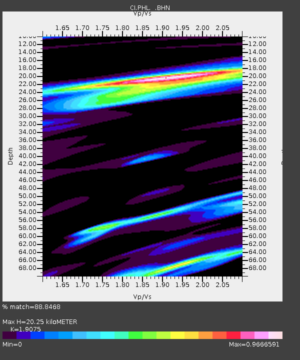
| Estimated Moho Depth: |
20.25 km |
| Estimated Crust Vp/Vs: |
1.91 |
| Assumed Crust Vp: |
6.183 km/s |
| Estimated Crust Vs: |
3.241 km/s |
| Estimated Crust Poisson's Ratio: |
0.31 |
|
| Radial Match: |
88.8468 % |
| Radial Bump: |
400 |
| Transverse Match: |
70.67905 % |
| Transverse Bump: |
400 |
| SOD ConfigId: |
2422 |
| Insert Time: |
2010-02-26 02:11:19.772 +0000 |
| GWidth: |
2.5 |
| Max Bumps: |
400 |
| Tol: |
0.001 |
|

Signal To Noise
| Channel | StoN | STA | LTA |
| CI:PHL: :BHN:20051213T03:27:13.861018Z | 0.84370965 | 3.2422562E-7 | 3.8428578E-7 |
| CI:PHL: :BHE:20051213T03:27:13.861018Z | 0.86814016 | 1.9950674E-7 | 2.2980936E-7 |
| CI:PHL: :BHZ:20051213T03:27:13.861018Z | 3.105281 | 9.010334E-7 | 2.901616E-7 |
| Arrivals |
| Ps | 3.1 SECOND |
| PpPs | 9.3 SECOND |
| PsPs/PpSs | 12 SECOND |


