You are here: Home > Network List > CI - Caltech Regional Seismic Network Stations List
> Station PHL Parkhill, California, USA > Earthquake Result Viewer
PHL Parkhill, California, USA - Earthquake Result Viewer
| Earthquake location: |
Chile-Bolivia Border Region |
| Earthquake latitude/longitude: |
-22.3/-67.9 |
| Earthquake time(UTC): |
2005/11/17 (321) 19:26:56 GMT |
| Earthquake Depth: |
163 km |
| Earthquake Magnitude: |
6.0 MB, 6.9 MW, 6.8 MW |
| Earthquake Catalog/Contributor: |
WHDF/NEIC |
|
| Network: |
CI Caltech Regional Seismic Network |
| Station: |
PHL Parkhill, California, USA |
| Lat/Lon: |
35.41 N/120.55 W |
| Elevation: |
351 m |
|
| Distance: |
76.1 deg |
| Az: |
317.997 deg |
| Baz: |
130.664 deg |
| Ray Param: |
0.05084286 |
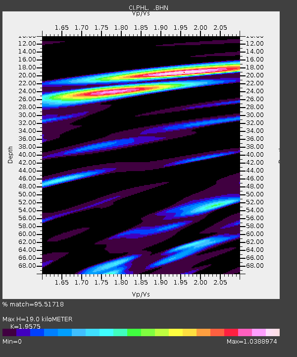
| Estimated Moho Depth: |
19.0 km |
| Estimated Crust Vp/Vs: |
1.96 |
| Assumed Crust Vp: |
6.183 km/s |
| Estimated Crust Vs: |
3.158 km/s |
| Estimated Crust Poisson's Ratio: |
0.32 |
|
| Radial Match: |
95.51718 % |
| Radial Bump: |
375 |
| Transverse Match: |
91.65292 % |
| Transverse Bump: |
400 |
| SOD ConfigId: |
2422 |
| Insert Time: |
2010-02-26 02:11:20.912 +0000 |
| GWidth: |
2.5 |
| Max Bumps: |
400 |
| Tol: |
0.001 |
|

Signal To Noise
| Channel | StoN | STA | LTA |
| CI:PHL: :BHN:20051117T19:37:54.911018Z | 7.899795 | 1.4038726E-6 | 1.7771E-7 |
| CI:PHL: :BHE:20051117T19:37:54.911018Z | 5.4451704 | 7.29597E-7 | 1.3398974E-7 |
| CI:PHL: :BHZ:20051117T19:37:54.911018Z | 30.017378 | 4.1904627E-6 | 1.3960123E-7 |
| Arrivals |
| Ps | 3.0 SECOND |
| PpPs | 8.9 SECOND |
| PsPs/PpSs | 12 SECOND |


