You are here: Home > Network List > TA - USArray Transportable Network (new EarthScope stations) Stations List
> Station Y24A Capitan, NM, USA > Earthquake Result Viewer
Y24A Capitan, NM, USA - Earthquake Result Viewer

| Earthquake location: |
Samoa Islands Region |
| Earthquake latitude/longitude: |
-16.2/-173.0 |
| Earthquake time(UTC): |
2009/09/29 (272) 18:21:42 GMT |
| Earthquake Depth: |
10 km |
| Earthquake Magnitude: |
5.8 MB |
| Earthquake Catalog/Contributor: |
WHDF/NEIC |
|
| Network: |
TA USArray Transportable Network (new EarthScope stations) |
| Station: |
Y24A Capitan, NM, USA |
| Lat/Lon: |
33.93 N/105.44 W |
| Elevation: |
1827 m |
|
| Distance: |
81.3 deg |
| Az: |
51.018 deg |
| Baz: |
243.922 deg |
| Ray Param: |
0.047677517 |
| Estimated Moho Depth: |
39.0 km |
| Estimated Crust Vp/Vs: |
1.87 |
| Assumed Crust Vp: |
6.232 km/s |
| Estimated Crust Vs: |
3.341 km/s |
| Estimated Crust Poisson's Ratio: |
0.30 |
|
| Radial Match: |
91.070244 % |
| Radial Bump: |
332 |
| Transverse Match: |
84.713135 % |
| Transverse Bump: |
325 |
| SOD ConfigId: |
2622 |
| Insert Time: |
2010-03-06 13:47:45.998 +0000 |
| GWidth: |
2.5 |
| Max Bumps: |
400 |
| Tol: |
0.001 |
|
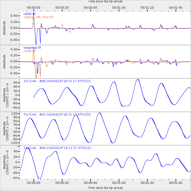
Signal To Noise
| Channel | StoN | STA | LTA |
| TA:Y24A: :BHZ:20090929T18:33:27.475015Z | 0.6328069 | 4.6342546E-5 | 7.3233314E-5 |
| TA:Y24A: :BHN:20090929T18:33:27.475015Z | 1.8363234 | 4.0625702E-5 | 2.2123391E-5 |
| TA:Y24A: :BHE:20090929T18:33:27.475015Z | 1.3815166 | 5.6023484E-5 | 4.055216E-5 |
| Arrivals |
| Ps | 5.5 SECOND |
| PpPs | 17 SECOND |
| PsPs/PpSs | 23 SECOND |


