You are here: Home > Network List > TA - USArray Transportable Network (new EarthScope stations) Stations List
> Station Y24A Capitan, NM, USA > Earthquake Result Viewer
Y24A Capitan, NM, USA - Earthquake Result Viewer
| Earthquake location: |
North Of Svalbard |
| Earthquake latitude/longitude: |
80.3/-1.9 |
| Earthquake time(UTC): |
2009/03/06 (065) 10:50:29 GMT |
| Earthquake Depth: |
9.0 km |
| Earthquake Magnitude: |
6.6 MB, 6.5 MS, 6.5 MW, 6.4 MW |
| Earthquake Catalog/Contributor: |
WHDF/NEIC |
|
| Network: |
TA USArray Transportable Network (new EarthScope stations) |
| Station: |
Y24A Capitan, NM, USA |
| Lat/Lon: |
33.93 N/105.44 W |
| Elevation: |
1827 m |
|
| Distance: |
59.0 deg |
| Az: |
289.515 deg |
| Baz: |
11.056 deg |
| Ray Param: |
0.062456455 |
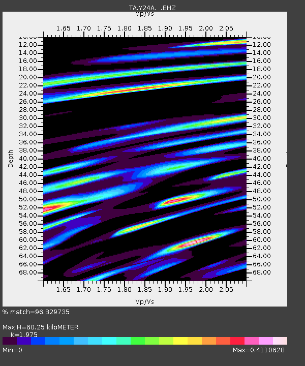
| Estimated Moho Depth: |
60.25 km |
| Estimated Crust Vp/Vs: |
1.98 |
| Assumed Crust Vp: |
6.232 km/s |
| Estimated Crust Vs: |
3.155 km/s |
| Estimated Crust Poisson's Ratio: |
0.33 |
|
| Radial Match: |
96.829735 % |
| Radial Bump: |
328 |
| Transverse Match: |
89.95457 % |
| Transverse Bump: |
400 |
| SOD ConfigId: |
2658 |
| Insert Time: |
2010-03-06 13:48:02.265 +0000 |
| GWidth: |
2.5 |
| Max Bumps: |
400 |
| Tol: |
0.001 |
|

Signal To Noise
| Channel | StoN | STA | LTA |
| TA:Y24A: :BHZ:20090306T10:59:58.475002Z | 10.326026 | 3.5276428E-6 | 3.416264E-7 |
| TA:Y24A: :BHN:20090306T10:59:58.475002Z | 14.136565 | 1.961421E-6 | 1.3874806E-7 |
| TA:Y24A: :BHE:20090306T10:59:58.475002Z | 2.5107071 | 5.400533E-7 | 2.1510009E-7 |
| Arrivals |
| Ps | 9.8 SECOND |
| PpPs | 28 SECOND |
| PsPs/PpSs | 37 SECOND |


