You are here: Home > Network List > TA - USArray Transportable Network (new EarthScope stations) Stations List
> Station Y24A Capitan, NM, USA > Earthquake Result Viewer
Y24A Capitan, NM, USA - Earthquake Result Viewer

| Earthquake location: |
West Chile Rise |
| Earthquake latitude/longitude: |
-41.7/-84.0 |
| Earthquake time(UTC): |
2009/06/10 (161) 23:13:21 GMT |
| Earthquake Depth: |
10 km |
| Earthquake Magnitude: |
5.7 MB, 5.2 MS, 5.7 MW, 5.6 MW |
| Earthquake Catalog/Contributor: |
WHDF/NEIC |
|
| Network: |
TA USArray Transportable Network (new EarthScope stations) |
| Station: |
Y24A Capitan, NM, USA |
| Lat/Lon: |
33.93 N/105.44 W |
| Elevation: |
1827 m |
|
| Distance: |
77.8 deg |
| Az: |
341.883 deg |
| Baz: |
163.741 deg |
| Ray Param: |
0.05006866 |
| Estimated Moho Depth: |
46.0 km |
| Estimated Crust Vp/Vs: |
1.84 |
| Assumed Crust Vp: |
6.232 km/s |
| Estimated Crust Vs: |
3.382 km/s |
| Estimated Crust Poisson's Ratio: |
0.29 |
|
| Radial Match: |
96.992165 % |
| Radial Bump: |
301 |
| Transverse Match: |
95.959854 % |
| Transverse Bump: |
246 |
| SOD ConfigId: |
2648 |
| Insert Time: |
2010-03-06 13:48:06.740 +0000 |
| GWidth: |
2.5 |
| Max Bumps: |
400 |
| Tol: |
0.001 |
|
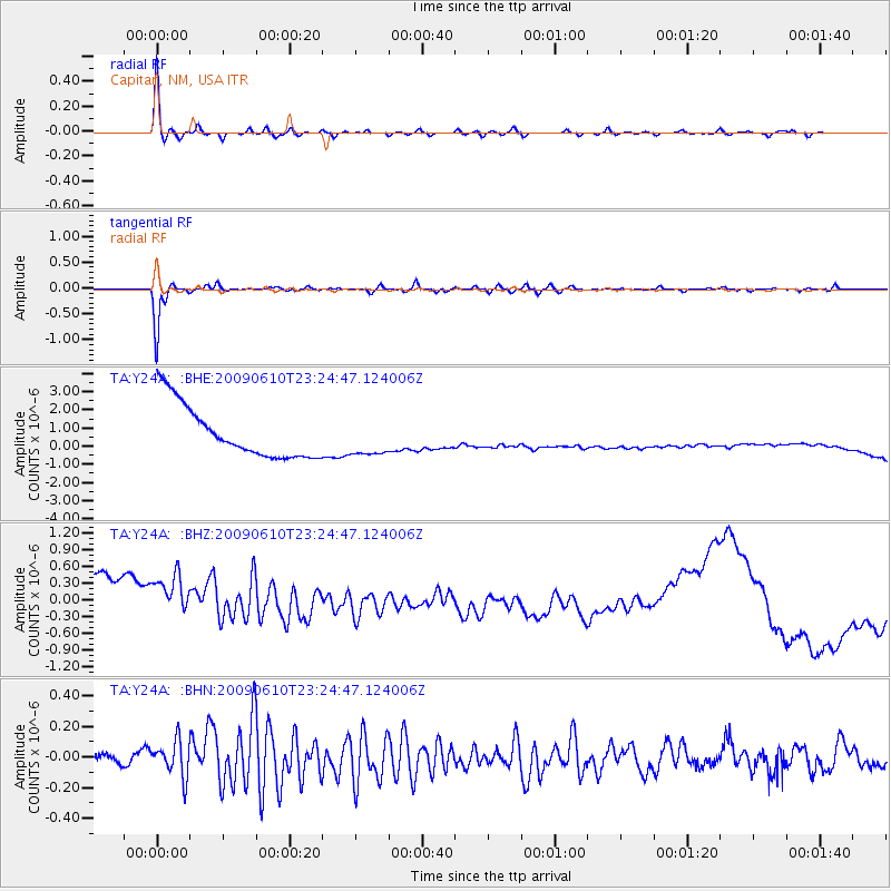
Signal To Noise
| Channel | StoN | STA | LTA |
| TA:Y24A: :BHZ:20090610T23:24:47.124006Z | 0.73621637 | 8.3741315E-7 | 1.1374552E-6 |
| TA:Y24A: :BHN:20090610T23:24:47.124006Z | 1.7197664 | 1.2185154E-7 | 7.085354E-8 |
| TA:Y24A: :BHE:20090610T23:24:47.124006Z | 0.686613 | 9.902893E-7 | 1.4422816E-6 |
| Arrivals |
| Ps | 6.4 SECOND |
| PpPs | 20 SECOND |
| PsPs/PpSs | 27 SECOND |


