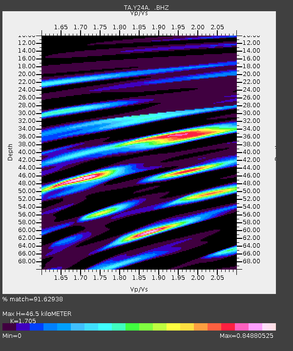
Y24A Capitan, NM, USA - Earthquake Result Viewer
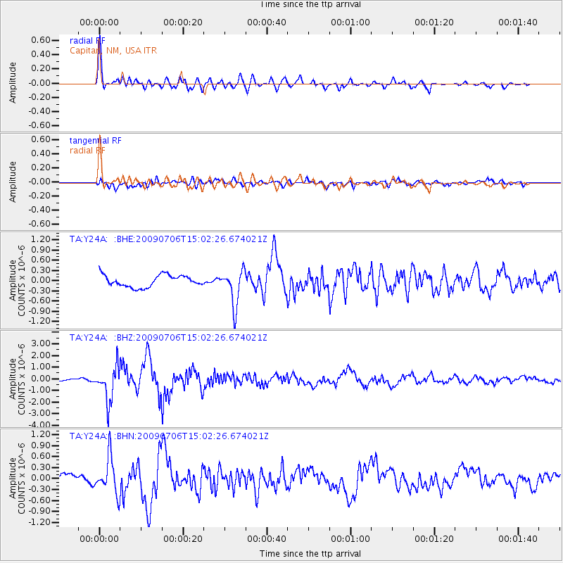
Earthquake location: Rat Islands, Aleutian Islands
Earthquake latitude/longitude: 50.4/177.0
Earthquake time(UTC): 2009/07/06 (187) 14:53:12 GMT
Earthquake Depth: 22 km
Earthquake Magnitude: 6.0 MB, 5.8 MS, 6.1 MW, 6.0 MW
Earthquake Catalog/Contributor: WHDF/NEIC
Network: TA USArray Transportable Network (new EarthScope stations)
Station: Y24A Capitan, NM, USA
Lat/Lon: 33.93 N/105.44 W
Elevation: 1827 m
Distance: 57.2 deg
Az: 74.993 deg
Baz: 312.024 deg
Ray Param: 0.063606545
Estimated Moho Depth: 46.5 km
Estimated Crust Vp/Vs: 1.71
Assumed Crust Vp: 6.232 km/s
Estimated Crust Vs: 3.655 km/s
Estimated Crust Poisson's Ratio: 0.24
Radial Match: 91.62938 %
Radial Bump: 400
Transverse Match: 66.944565 %
Transverse Bump: 400
SOD ConfigId: 2648
Insert Time: 2010-03-06 13:48:18.288 +0000
GWidth: 2.5
Max Bumps: 400
Tol: 0.001

Signal To Noise

ChannelStoNSTALTA
TA:Y24A: :BHZ:20090706T15:02:26.674021Z14.2392411.4979505E-61.05198765E-7
TA:Y24A: :BHN:20090706T15:02:26.674021Z3.77914715.087422E-71.3461825E-7
TA:Y24A: :BHE:20090706T15:02:26.674021Z3.15684085.4153173E-71.7154231E-7
Arrivals
Ps5.5 SECOND
PpPs19 SECOND
PsPs/PpSs25 SECOND