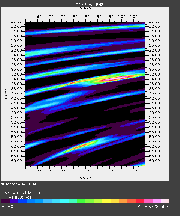
Y24A Capitan, NM, USA - Earthquake Result Viewer
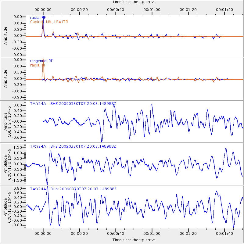
Earthquake location: Kodiak Island Region, Alaska
Earthquake latitude/longitude: 56.5/-152.7
Earthquake time(UTC): 2009/03/30 (089) 07:13:07 GMT
Earthquake Depth: 21 km
Earthquake Magnitude: 5.9 MB, 5.9 MS, 5.9 MW, 5.9 MW
Earthquake Catalog/Contributor: WHDF/NEIC
Network: TA USArray Transportable Network (new EarthScope stations)
Station: Y24A Capitan, NM, USA
Lat/Lon: 33.93 N/105.44 W
Elevation: 1827 m
Distance: 39.2 deg
Az: 104.825 deg
Baz: 319.916 deg
Ray Param: 0.07508675
Estimated Moho Depth: 33.5 km
Estimated Crust Vp/Vs: 1.97
Assumed Crust Vp: 6.232 km/s
Estimated Crust Vs: 3.159 km/s
Estimated Crust Poisson's Ratio: 0.33
Radial Match: 84.76947 %
Radial Bump: 271
Transverse Match: 50.74075 %
Transverse Bump: 400
SOD ConfigId: 2658
Insert Time: 2010-03-06 13:48:22.390 +0000
GWidth: 2.5
Max Bumps: 400
Tol: 0.001

Signal To Noise

ChannelStoNSTALTA
TA:Y24A: :BHZ:20090330T07:20:03.148988Z8.7854778.8564013E-71.008073E-7
TA:Y24A: :BHN:20090330T07:20:03.148988Z4.1400124.778357E-71.1541893E-7
TA:Y24A: :BHE:20090330T07:20:03.148988Z4.46179683.599928E-78.068338E-8
Arrivals
Ps5.6 SECOND
PpPs15 SECOND
PsPs/PpSs21 SECOND