You are here: Home > Network List > IU - Global Seismograph Network (GSN - IRIS/USGS) Stations List
> Station RSSD Black Hills, South Dakota, USA > Earthquake Result Viewer
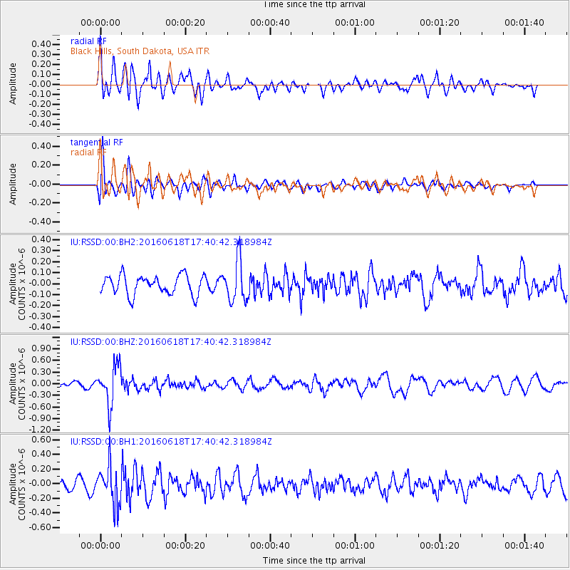
RSSD Black Hills, South Dakota, USA - Earthquake Result Viewer
*The percent match for this event was below the threshold and hence no stack was calculated.
| Earthquake location: |
Chile-Argentina Border Region |
| Earthquake latitude/longitude: |
-24.2/-67.1 |
| Earthquake time(UTC): |
2016/06/18 (170) 17:29:44 GMT |
| Earthquake Depth: |
167 km |
| Earthquake Magnitude: |
5.5 MB |
| Earthquake Catalog/Contributor: |
NEIC PDE/NEIC COMCAT |
|
| Network: |
IU Global Seismograph Network (GSN - IRIS/USGS) |
| Station: |
RSSD Black Hills, South Dakota, USA |
| Lat/Lon: |
44.12 N/104.04 W |
| Elevation: |
2090 m |
|
| Distance: |
76.0 deg |
| Az: |
333.497 deg |
| Baz: |
145.546 deg |
| Ray Param: |
$rayparam |
*The percent match for this event was below the threshold and hence was not used in the summary stack. |
|
| Radial Match: |
78.179474 % |
| Radial Bump: |
400 |
| Transverse Match: |
62.53823 % |
| Transverse Bump: |
400 |
| SOD ConfigId: |
1634031 |
| Insert Time: |
2016-07-02 17:33:42.906 +0000 |
| GWidth: |
2.5 |
| Max Bumps: |
400 |
| Tol: |
0.001 |
|
Signal To Noise
| Channel | StoN | STA | LTA |
| IU:RSSD:00:BHZ:20160618T17:40:42.318984Z | 6.015688 | 5.063109E-7 | 8.4165094E-8 |
| IU:RSSD:00:BH1:20160618T17:40:42.318984Z | 3.1724107 | 2.6697958E-7 | 8.415669E-8 |
| IU:RSSD:00:BH2:20160618T17:40:42.318984Z | 2.1838865 | 1.9201164E-7 | 8.792199E-8 |
| Arrivals |
| Ps | |
| PpPs | |
| PsPs/PpSs | |


